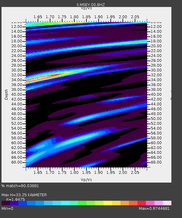
MSEY Mahe, Seychelles - Earthquake Result Viewer

Earthquake location: Off W Coast Of Northern Sumatra
Earthquake latitude/longitude: 2.9/95.6
Earthquake time(UTC): 2005/02/26 (057) 12:56:52 GMT
Earthquake Depth: 36 km
Earthquake Magnitude: 6.0 MB, 6.7 MS, 6.8 MW, 6.7 MW
Earthquake Catalog/Contributor: WHDF/NEIC
Network: II Global Seismograph Network (GSN - IRIS/IDA)
Station: MSEY Mahe, Seychelles
Lat/Lon: 4.67 S/55.48 E
Elevation: 475 m
Distance: 40.8 deg
Az: 259.48 deg
Baz: 80.122 deg
Ray Param: 0.0741235
Estimated Moho Depth: 33.25 km
Estimated Crust Vp/Vs: 1.65
Assumed Crust Vp: 6.303 km/s
Estimated Crust Vs: 3.826 km/s
Estimated Crust Poisson's Ratio: 0.21
Radial Match: 90.03881 %
Radial Bump: 334
Transverse Match: 69.80785 %
Transverse Bump: 400
SOD ConfigId: 590571
Insert Time: 2013-09-25 11:04:04.984 +0000
GWidth: 2.5
Max Bumps: 400
Tol: 0.001

Signal To Noise

ChannelStoNSTALTA
II:MSEY:00:BHZ:20050226T13:03:59.916997Z3.38907818.249509E-72.4341455E-7
II:MSEY:00:BH1:20050226T13:03:59.916997Z2.86843184.773538E-71.664163E-7
II:MSEY:00:BH2:20050226T13:03:59.916997Z0.848545431.634052E-71.9257095E-7
Arrivals
Ps3.7 SECOND
PpPs13 SECOND
PsPs/PpSs17 SECOND