You are here: Home > Network List > II - Global Seismograph Network (GSN - IRIS/IDA) Stations List
> Station MSEY Mahe, Seychelles > Earthquake Result Viewer
MSEY Mahe, Seychelles - Earthquake Result Viewer
| Earthquake location: |
Southern Iran |
| Earthquake latitude/longitude: |
27.1/61.9 |
| Earthquake time(UTC): |
2005/03/13 (072) 03:31:23 GMT |
| Earthquake Depth: |
54 km |
| Earthquake Magnitude: |
5.9 MB, 5.4 MS, 6.0 MW, 6.0 MW |
| Earthquake Catalog/Contributor: |
WHDF/NEIC |
|
| Network: |
II Global Seismograph Network (GSN - IRIS/IDA) |
| Station: |
MSEY Mahe, Seychelles |
| Lat/Lon: |
4.67 S/55.48 E |
| Elevation: |
475 m |
|
| Distance: |
32.2 deg |
| Az: |
192.055 deg |
| Baz: |
10.764 deg |
| Ray Param: |
0.07863656 |
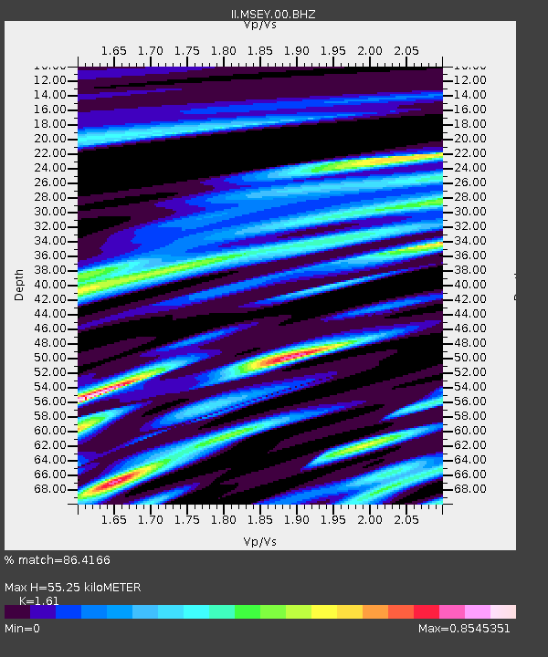
| Estimated Moho Depth: |
55.25 km |
| Estimated Crust Vp/Vs: |
1.61 |
| Assumed Crust Vp: |
6.303 km/s |
| Estimated Crust Vs: |
3.915 km/s |
| Estimated Crust Poisson's Ratio: |
0.19 |
|
| Radial Match: |
86.4166 % |
| Radial Bump: |
400 |
| Transverse Match: |
70.963684 % |
| Transverse Bump: |
400 |
| SOD ConfigId: |
590571 |
| Insert Time: |
2013-09-25 11:22:14.658 +0000 |
| GWidth: |
2.5 |
| Max Bumps: |
400 |
| Tol: |
0.001 |
|

Signal To Noise
| Channel | StoN | STA | LTA |
| II:MSEY:00:BHZ:20050313T03:37:15.604987Z | 5.236148 | 3.8920228E-7 | 7.432989E-8 |
| II:MSEY:00:BH1:20050313T03:37:15.604987Z | 1.5668141 | 1.5067627E-7 | 9.61673E-8 |
| II:MSEY:00:BH2:20050313T03:37:15.604987Z | 4.184153 | 3.0127234E-7 | 7.200318E-8 |
| Arrivals |
| Ps | 5.8 SECOND |
| PpPs | 21 SECOND |
| PsPs/PpSs | 27 SECOND |


