You are here: Home > Network List > IU - Global Seismograph Network (GSN - IRIS/USGS) Stations List
> Station RSSD Black Hills, South Dakota, USA > Earthquake Result Viewer
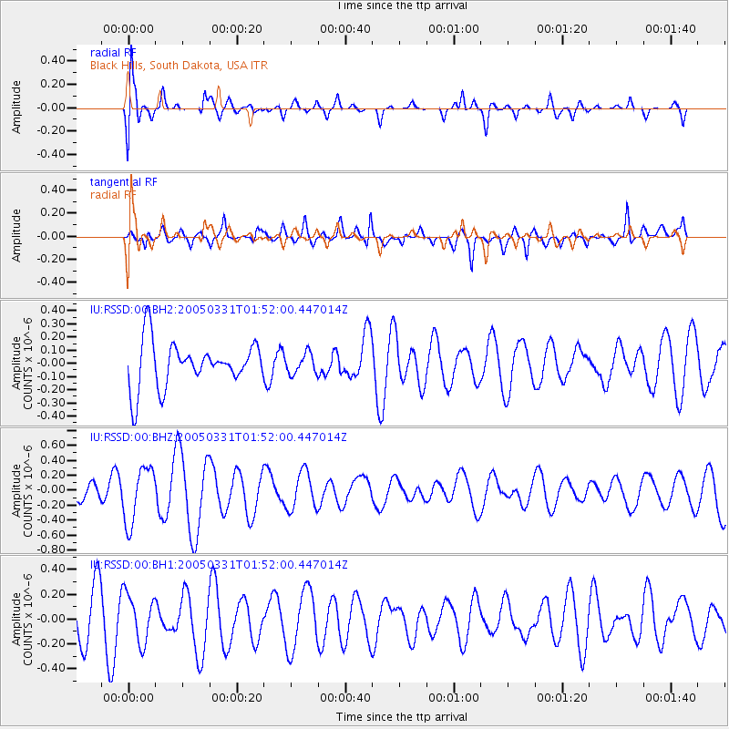
RSSD Black Hills, South Dakota, USA - Earthquake Result Viewer
*The percent match for this event was below the threshold and hence no stack was calculated.
| Earthquake location: |
Fiji Islands Region |
| Earthquake latitude/longitude: |
-18.5/176.0 |
| Earthquake time(UTC): |
2005/03/31 (090) 01:39:06 GMT |
| Earthquake Depth: |
10 km |
| Earthquake Magnitude: |
5.7 MW, 5.8 MS, 5.9 MW |
| Earthquake Catalog/Contributor: |
NEIC PDE/NEIC PDE-M |
|
| Network: |
IU Global Seismograph Network (GSN - IRIS/USGS) |
| Station: |
RSSD Black Hills, South Dakota, USA |
| Lat/Lon: |
44.12 N/104.04 W |
| Elevation: |
2060 m |
|
| Distance: |
95.7 deg |
| Az: |
45.458 deg |
| Baz: |
249.863 deg |
| Ray Param: |
$rayparam |
*The percent match for this event was below the threshold and hence was not used in the summary stack. |
|
| Radial Match: |
65.98853 % |
| Radial Bump: |
400 |
| Transverse Match: |
64.056145 % |
| Transverse Bump: |
400 |
| SOD ConfigId: |
590571 |
| Insert Time: |
2013-09-25 11:54:10.523 +0000 |
| GWidth: |
2.5 |
| Max Bumps: |
400 |
| Tol: |
0.001 |
|
Signal To Noise
| Channel | StoN | STA | LTA |
| IU:RSSD:00:BHZ:20050331T01:52:00.447014Z | 2.8938744 | 3.7692374E-7 | 1.3024882E-7 |
| IU:RSSD:00:BH1:20050331T01:52:00.447014Z | 1.0823247 | 1.9030247E-7 | 1.7582751E-7 |
| IU:RSSD:00:BH2:20050331T01:52:00.447014Z | 0.45088965 | 7.7996866E-8 | 1.7298437E-7 |
| Arrivals |
| Ps | |
| PpPs | |
| PsPs/PpSs | |


