You are here: Home > Network List > IU - Global Seismograph Network (GSN - IRIS/USGS) Stations List
> Station RSSD Black Hills, South Dakota, USA > Earthquake Result Viewer
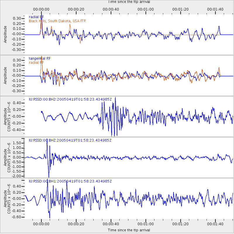
RSSD Black Hills, South Dakota, USA - Earthquake Result Viewer
*The percent match for this event was below the threshold and hence no stack was calculated.
| Earthquake location: |
Southeast Of Honshu, Japan |
| Earthquake latitude/longitude: |
29.6/138.9 |
| Earthquake time(UTC): |
2005/04/19 (109) 01:46:56 GMT |
| Earthquake Depth: |
426 km |
| Earthquake Magnitude: |
5.6 MB, 5.9 MW, 5.9 MW |
| Earthquake Catalog/Contributor: |
WHDF/NEIC |
|
| Network: |
IU Global Seismograph Network (GSN - IRIS/USGS) |
| Station: |
RSSD Black Hills, South Dakota, USA |
| Lat/Lon: |
44.12 N/104.04 W |
| Elevation: |
2060 m |
|
| Distance: |
86.8 deg |
| Az: |
39.964 deg |
| Baz: |
309.069 deg |
| Ray Param: |
$rayparam |
*The percent match for this event was below the threshold and hence was not used in the summary stack. |
|
| Radial Match: |
65.404434 % |
| Radial Bump: |
400 |
| Transverse Match: |
67.16245 % |
| Transverse Bump: |
400 |
| SOD ConfigId: |
590571 |
| Insert Time: |
2013-09-25 12:28:55.722 +0000 |
| GWidth: |
2.5 |
| Max Bumps: |
400 |
| Tol: |
0.001 |
|
Signal To Noise
| Channel | StoN | STA | LTA |
| IU:RSSD:00:BHZ:20050419T01:58:23.434985Z | 6.3083134 | 7.7725974E-7 | 1.2321198E-7 |
| IU:RSSD:00:BH1:20050419T01:58:23.434985Z | 2.8050644 | 2.5917447E-7 | 9.239519E-8 |
| IU:RSSD:00:BH2:20050419T01:58:23.434985Z | 1.2207799 | 9.395002E-8 | 7.6959026E-8 |
| Arrivals |
| Ps | |
| PpPs | |
| PsPs/PpSs | |


