You are here: Home > Network List > TA - USArray Transportable Network (new EarthScope stations) Stations List
> Station G65A Princeton, ME, USA > Earthquake Result Viewer
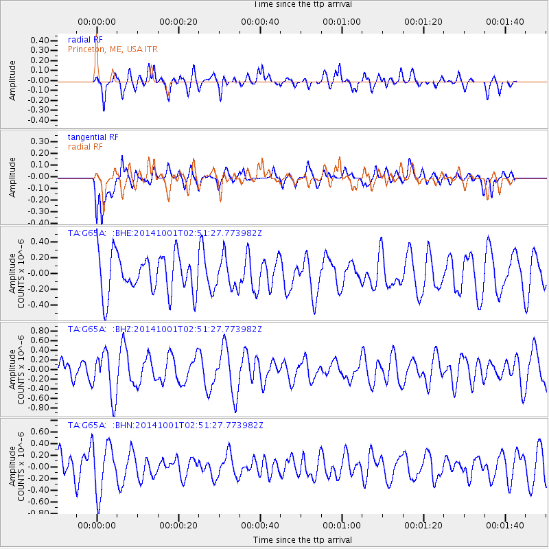
G65A Princeton, ME, USA - Earthquake Result Viewer
*The percent match for this event was below the threshold and hence no stack was calculated.
| Earthquake location: |
Sea Of Okhotsk |
| Earthquake latitude/longitude: |
52.2/151.9 |
| Earthquake time(UTC): |
2014/10/01 (274) 02:41:01 GMT |
| Earthquake Depth: |
558 km |
| Earthquake Magnitude: |
5.3 MW |
| Earthquake Catalog/Contributor: |
ISC/ISC |
|
| Network: |
TA USArray Transportable Network (new EarthScope stations) |
| Station: |
G65A Princeton, ME, USA |
| Lat/Lon: |
45.20 N/67.56 W |
| Elevation: |
78 m |
|
| Distance: |
77.2 deg |
| Az: |
27.407 deg |
| Baz: |
336.368 deg |
| Ray Param: |
$rayparam |
*The percent match for this event was below the threshold and hence was not used in the summary stack. |
|
| Radial Match: |
52.420174 % |
| Radial Bump: |
400 |
| Transverse Match: |
57.301926 % |
| Transverse Bump: |
400 |
| SOD ConfigId: |
3390531 |
| Insert Time: |
2019-04-14 07:06:22.157 +0000 |
| GWidth: |
2.5 |
| Max Bumps: |
400 |
| Tol: |
0.001 |
|
Signal To Noise
| Channel | StoN | STA | LTA |
| TA:G65A: :BHZ:20141001T02:51:27.773982Z | 3.19864 | 4.7877495E-7 | 1.4968079E-7 |
| TA:G65A: :BHN:20141001T02:51:27.773982Z | 2.49812 | 4.2305885E-7 | 1.6935088E-7 |
| TA:G65A: :BHE:20141001T02:51:27.773982Z | 0.7927673 | 1.9555942E-7 | 2.466795E-7 |
| Arrivals |
| Ps | |
| PpPs | |
| PsPs/PpSs | |


