You are here: Home > Network List > TA - USArray Transportable Network (new EarthScope stations) Stations List
> Station T57A Hurt, VA, USA > Earthquake Result Viewer
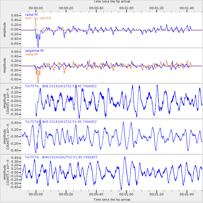
T57A Hurt, VA, USA - Earthquake Result Viewer
*The percent match for this event was below the threshold and hence no stack was calculated.
| Earthquake location: |
Sea Of Okhotsk |
| Earthquake latitude/longitude: |
52.2/151.9 |
| Earthquake time(UTC): |
2014/10/01 (274) 02:41:01 GMT |
| Earthquake Depth: |
558 km |
| Earthquake Magnitude: |
5.3 MW |
| Earthquake Catalog/Contributor: |
ISC/ISC |
|
| Network: |
TA USArray Transportable Network (new EarthScope stations) |
| Station: |
T57A Hurt, VA, USA |
| Lat/Lon: |
37.00 N/79.25 W |
| Elevation: |
230 m |
|
| Distance: |
80.6 deg |
| Az: |
39.164 deg |
| Baz: |
330.943 deg |
| Ray Param: |
$rayparam |
*The percent match for this event was below the threshold and hence was not used in the summary stack. |
|
| Radial Match: |
60.99312 % |
| Radial Bump: |
400 |
| Transverse Match: |
54.194626 % |
| Transverse Bump: |
400 |
| SOD ConfigId: |
3390531 |
| Insert Time: |
2019-04-14 07:06:56.314 +0000 |
| GWidth: |
2.5 |
| Max Bumps: |
400 |
| Tol: |
0.001 |
|
Signal To Noise
| Channel | StoN | STA | LTA |
| TA:T57A: :BHZ:20141001T02:51:45.749995Z | 2.6608944 | 3.010583E-7 | 1.1314177E-7 |
| TA:T57A: :BHN:20141001T02:51:45.749995Z | 1.308167 | 1.8731313E-7 | 1.4318748E-7 |
| TA:T57A: :BHE:20141001T02:51:45.749995Z | 1.4599938 | 1.8246212E-7 | 1.2497458E-7 |
| Arrivals |
| Ps | |
| PpPs | |
| PsPs/PpSs | |


