You are here: Home > Network List > IU - Global Seismograph Network (GSN - IRIS/USGS) Stations List
> Station RSSD Black Hills, South Dakota, USA > Earthquake Result Viewer
RSSD Black Hills, South Dakota, USA - Earthquake Result Viewer
| Earthquake location: |
Peru-Ecuador Border Region |
| Earthquake latitude/longitude: |
-3.3/-81.0 |
| Earthquake time(UTC): |
2005/05/21 (141) 05:11:35 GMT |
| Earthquake Depth: |
40 km |
| Earthquake Magnitude: |
5.9 MB, 5.9 MS, 6.4 MW, 6.3 MW |
| Earthquake Catalog/Contributor: |
WHDF/NEIC |
|
| Network: |
IU Global Seismograph Network (GSN - IRIS/USGS) |
| Station: |
RSSD Black Hills, South Dakota, USA |
| Lat/Lon: |
44.12 N/104.04 W |
| Elevation: |
2060 m |
|
| Distance: |
51.5 deg |
| Az: |
338.889 deg |
| Baz: |
150.048 deg |
| Ray Param: |
0.06727008 |
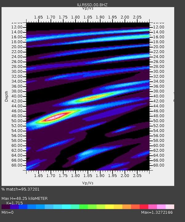
| Estimated Moho Depth: |
48.25 km |
| Estimated Crust Vp/Vs: |
1.72 |
| Assumed Crust Vp: |
6.242 km/s |
| Estimated Crust Vs: |
3.64 km/s |
| Estimated Crust Poisson's Ratio: |
0.24 |
|
| Radial Match: |
95.37201 % |
| Radial Bump: |
304 |
| Transverse Match: |
88.611404 % |
| Transverse Bump: |
400 |
| SOD ConfigId: |
590571 |
| Insert Time: |
2013-09-25 13:06:30.664 +0000 |
| GWidth: |
2.5 |
| Max Bumps: |
400 |
| Tol: |
0.001 |
|
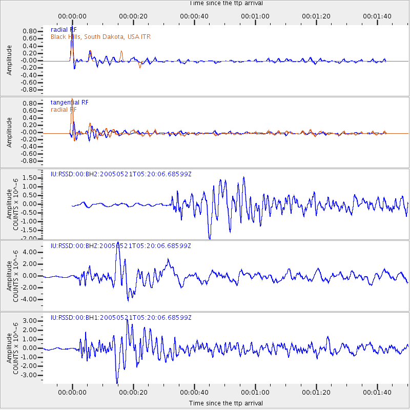
Signal To Noise
| Channel | StoN | STA | LTA |
| IU:RSSD:00:BHZ:20050521T05:20:06.68599Z | 5.4675245 | 5.5767794E-7 | 1.01998246E-7 |
| IU:RSSD:00:BH1:20050521T05:20:06.68599Z | 6.2484016 | 5.7168546E-7 | 9.149308E-8 |
| IU:RSSD:00:BH2:20050521T05:20:06.68599Z | 3.2264361 | 2.3408242E-7 | 7.255139E-8 |
| Arrivals |
| Ps | 5.8 SECOND |
| PpPs | 20 SECOND |
| PsPs/PpSs | 26 SECOND |


