You are here: Home > Network List > IU - Global Seismograph Network (GSN - IRIS/USGS) Stations List
> Station RSSD Black Hills, South Dakota, USA > Earthquake Result Viewer
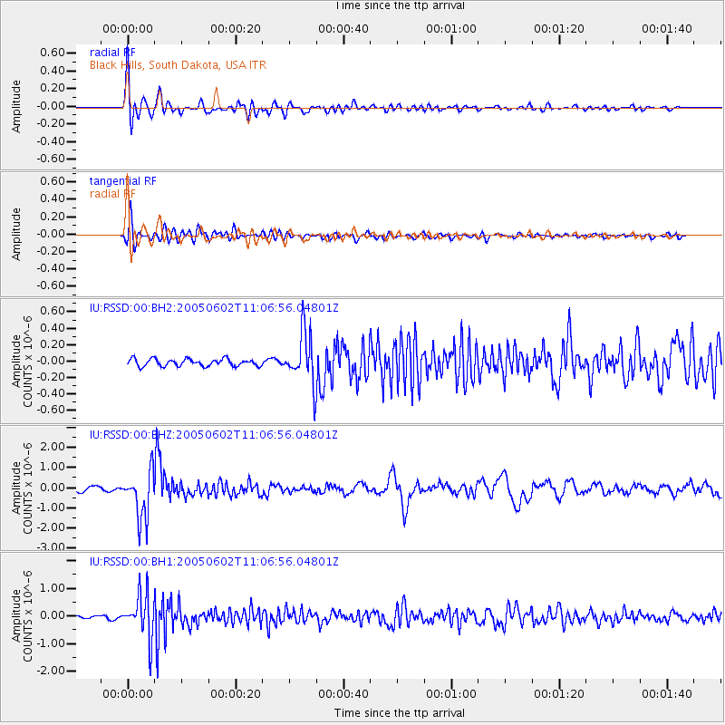
RSSD Black Hills, South Dakota, USA - Earthquake Result Viewer
*The percent match for this event was below the threshold and hence no stack was calculated.
| Earthquake location: |
Chile-Argentina Border Region |
| Earthquake latitude/longitude: |
-24.2/-67.0 |
| Earthquake time(UTC): |
2005/06/02 (153) 10:56:01 GMT |
| Earthquake Depth: |
196 km |
| Earthquake Magnitude: |
6.1 MW, 5.7 MB, 6.0 MW |
| Earthquake Catalog/Contributor: |
NEIC PDE/NEIC PDE-M |
|
| Network: |
IU Global Seismograph Network (GSN - IRIS/USGS) |
| Station: |
RSSD Black Hills, South Dakota, USA |
| Lat/Lon: |
44.12 N/104.04 W |
| Elevation: |
2060 m |
|
| Distance: |
76.0 deg |
| Az: |
333.446 deg |
| Baz: |
145.479 deg |
| Ray Param: |
$rayparam |
*The percent match for this event was below the threshold and hence was not used in the summary stack. |
|
| Radial Match: |
90.62721 % |
| Radial Bump: |
400 |
| Transverse Match: |
86.99955 % |
| Transverse Bump: |
400 |
| SOD ConfigId: |
590571 |
| Insert Time: |
2013-09-25 13:14:50.766 +0000 |
| GWidth: |
2.5 |
| Max Bumps: |
400 |
| Tol: |
0.001 |
|
Signal To Noise
| Channel | StoN | STA | LTA |
| IU:RSSD:00:BHZ:20050602T11:06:56.04801Z | 12.695124 | 1.2000621E-6 | 9.452938E-8 |
| IU:RSSD:00:BH1:20050602T11:06:56.04801Z | 21.062347 | 7.8859654E-7 | 3.7441055E-8 |
| IU:RSSD:00:BH2:20050602T11:06:56.04801Z | 7.247356 | 3.1389337E-7 | 4.3311434E-8 |
| Arrivals |
| Ps | |
| PpPs | |
| PsPs/PpSs | |


