You are here: Home > Network List > IU - Global Seismograph Network (GSN - IRIS/USGS) Stations List
> Station POHA Pohakuloa, Hawaii, USA > Earthquake Result Viewer
POHA Pohakuloa, Hawaii, USA - Earthquake Result Viewer
| Earthquake location: |
Northern Chile |
| Earthquake latitude/longitude: |
-20.0/-69.2 |
| Earthquake time(UTC): |
2005/06/13 (164) 22:44:33 GMT |
| Earthquake Depth: |
116 km |
| Earthquake Magnitude: |
6.8 MB, 7.8 MW, 7.8 MW |
| Earthquake Catalog/Contributor: |
WHDF/NEIC |
|
| Network: |
IU Global Seismograph Network (GSN - IRIS/USGS) |
| Station: |
POHA Pohakuloa, Hawaii, USA |
| Lat/Lon: |
19.76 N/155.53 W |
| Elevation: |
1967 m |
|
| Distance: |
93.3 deg |
| Az: |
289.697 deg |
| Baz: |
109.925 deg |
| Ray Param: |
0.041224457 |
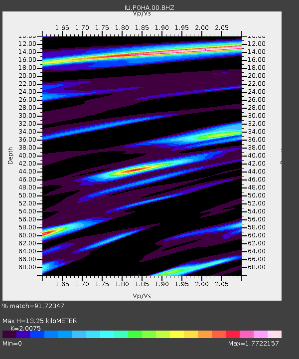
| Estimated Moho Depth: |
13.25 km |
| Estimated Crust Vp/Vs: |
2.01 |
| Assumed Crust Vp: |
5.195 km/s |
| Estimated Crust Vs: |
2.588 km/s |
| Estimated Crust Poisson's Ratio: |
0.33 |
|
| Radial Match: |
91.72347 % |
| Radial Bump: |
400 |
| Transverse Match: |
86.301056 % |
| Transverse Bump: |
400 |
| SOD ConfigId: |
590571 |
| Insert Time: |
2013-09-25 13:31:03.810 +0000 |
| GWidth: |
2.5 |
| Max Bumps: |
400 |
| Tol: |
0.001 |
|
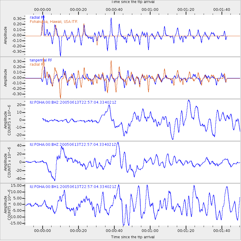
Signal To Noise
| Channel | StoN | STA | LTA |
| IU:POHA:00:BHZ:20050613T22:57:04.334021Z | 10.675947 | 1.341294E-5 | 1.25637E-6 |
| IU:POHA:00:BH1:20050613T22:57:04.334021Z | 1.3595111 | 2.023114E-6 | 1.4881186E-6 |
| IU:POHA:00:BH2:20050613T22:57:04.334021Z | 4.3441606 | 4.902625E-6 | 1.1285551E-6 |
| Arrivals |
| Ps | 2.6 SECOND |
| PpPs | 7.6 SECOND |
| PsPs/PpSs | 10 SECOND |


