You are here: Home > Network List > IW - Intermountain West Stations List
> Station MOOW Moose Ponds, Wyoming, USA > Earthquake Result Viewer
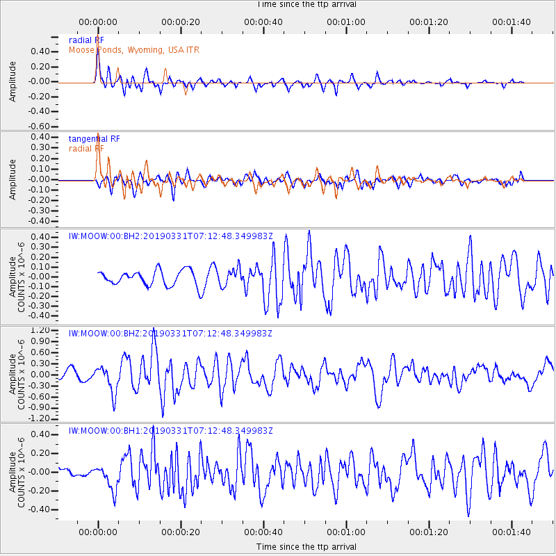
MOOW Moose Ponds, Wyoming, USA - Earthquake Result Viewer
*The percent match for this event was below the threshold and hence no stack was calculated.
| Earthquake location: |
Near Coast Of Ecuador |
| Earthquake latitude/longitude: |
-2.0/-80.8 |
| Earthquake time(UTC): |
2019/03/31 (090) 07:04:04 GMT |
| Earthquake Depth: |
19 km |
| Earthquake Magnitude: |
6.2 Mww |
| Earthquake Catalog/Contributor: |
NEIC PDE/us |
|
| Network: |
IW Intermountain West |
| Station: |
MOOW Moose Ponds, Wyoming, USA |
| Lat/Lon: |
43.75 N/110.74 W |
| Elevation: |
2128 m |
|
| Distance: |
52.8 deg |
| Az: |
333.016 deg |
| Baz: |
141.263 deg |
| Ray Param: |
$rayparam |
*The percent match for this event was below the threshold and hence was not used in the summary stack. |
|
| Radial Match: |
79.49277 % |
| Radial Bump: |
400 |
| Transverse Match: |
64.42287 % |
| Transverse Bump: |
400 |
| SOD ConfigId: |
3426611 |
| Insert Time: |
2019-04-14 07:12:04.666 +0000 |
| GWidth: |
2.5 |
| Max Bumps: |
400 |
| Tol: |
0.001 |
|
Signal To Noise
| Channel | StoN | STA | LTA |
| IW:MOOW:00:BHZ:20190331T07:12:48.349983Z | 3.7380466 | 3.7472455E-7 | 1.0024609E-7 |
| IW:MOOW:00:BH1:20190331T07:12:48.349983Z | 2.0684984 | 1.3600895E-7 | 6.57525E-8 |
| IW:MOOW:00:BH2:20190331T07:12:48.349983Z | 1.147511 | 8.5962284E-8 | 7.4911945E-8 |
| Arrivals |
| Ps | |
| PpPs | |
| PsPs/PpSs | |


