You are here: Home > Network List > IU - Global Seismograph Network (GSN - IRIS/USGS) Stations List
> Station RSSD Black Hills, South Dakota, USA > Earthquake Result Viewer
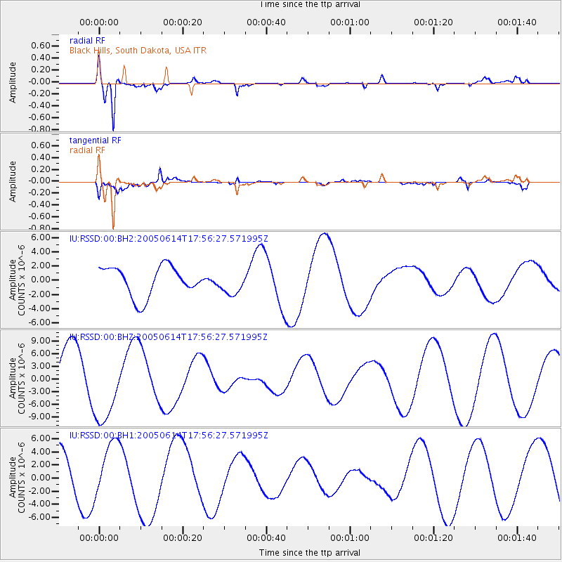
RSSD Black Hills, South Dakota, USA - Earthquake Result Viewer
*The percent match for this event was below the threshold and hence no stack was calculated.
| Earthquake location: |
Rat Islands, Aleutian Islands |
| Earthquake latitude/longitude: |
51.1/179.5 |
| Earthquake time(UTC): |
2005/06/14 (165) 17:48:07 GMT |
| Earthquake Depth: |
27 km |
| Earthquake Magnitude: |
5.5 MS |
| Earthquake Catalog/Contributor: |
NEIC PDE/NEIC PDE-M |
|
| Network: |
IU Global Seismograph Network (GSN - IRIS/USGS) |
| Station: |
RSSD Black Hills, South Dakota, USA |
| Lat/Lon: |
44.12 N/104.04 W |
| Elevation: |
2060 m |
|
| Distance: |
49.8 deg |
| Az: |
66.339 deg |
| Baz: |
306.617 deg |
| Ray Param: |
$rayparam |
*The percent match for this event was below the threshold and hence was not used in the summary stack. |
|
| Radial Match: |
92.6023 % |
| Radial Bump: |
400 |
| Transverse Match: |
54.35391 % |
| Transverse Bump: |
400 |
| SOD ConfigId: |
590571 |
| Insert Time: |
2013-09-25 13:36:43.780 +0000 |
| GWidth: |
2.5 |
| Max Bumps: |
400 |
| Tol: |
0.001 |
|
Signal To Noise
| Channel | StoN | STA | LTA |
| IU:RSSD:00:BHZ:20050614T17:56:27.571995Z | 1.6750778 | 8.638326E-6 | 5.1569705E-6 |
| IU:RSSD:00:BH1:20050614T17:56:27.571995Z | 1.2160912 | 4.1710605E-6 | 3.4298912E-6 |
| IU:RSSD:00:BH2:20050614T17:56:27.571995Z | 0.79586047 | 1.6572178E-6 | 2.082297E-6 |
| Arrivals |
| Ps | |
| PpPs | |
| PsPs/PpSs | |


