You are here: Home > Network List > IU - Global Seismograph Network (GSN - IRIS/USGS) Stations List
> Station POHA Pohakuloa, Hawaii, USA > Earthquake Result Viewer
POHA Pohakuloa, Hawaii, USA - Earthquake Result Viewer
| Earthquake location: |
Off Coast Of Northern California |
| Earthquake latitude/longitude: |
41.3/-126.0 |
| Earthquake time(UTC): |
2005/06/15 (166) 02:50:53 GMT |
| Earthquake Depth: |
10 km |
| Earthquake Magnitude: |
6.2 MB, 7.1 MS, 7.2 MW, 7.1 MW |
| Earthquake Catalog/Contributor: |
WHDF/NEIC |
|
| Network: |
IU Global Seismograph Network (GSN - IRIS/USGS) |
| Station: |
POHA Pohakuloa, Hawaii, USA |
| Lat/Lon: |
19.76 N/155.53 W |
| Elevation: |
1967 m |
|
| Distance: |
33.0 deg |
| Az: |
238.436 deg |
| Baz: |
42.97 deg |
| Ray Param: |
0.07838711 |
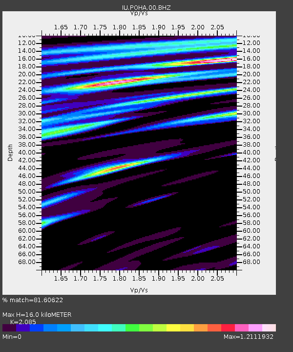
| Estimated Moho Depth: |
16.0 km |
| Estimated Crust Vp/Vs: |
2.09 |
| Assumed Crust Vp: |
5.195 km/s |
| Estimated Crust Vs: |
2.492 km/s |
| Estimated Crust Poisson's Ratio: |
0.35 |
|
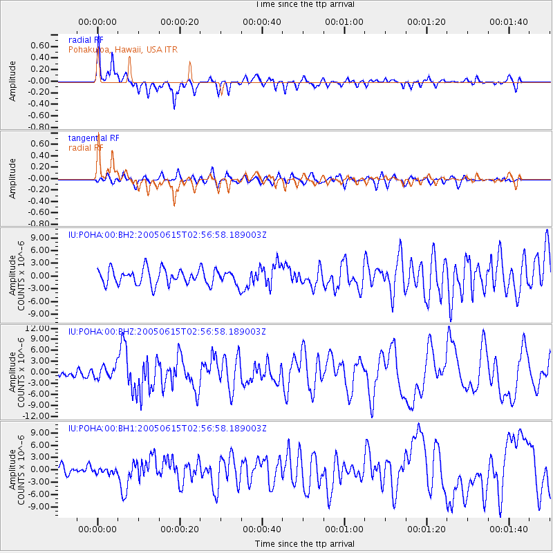
| Radial Match: |
81.60622 % |
| Radial Bump: |
377 |
| Transverse Match: |
63.591595 % |
| Transverse Bump: |
400 |
| SOD ConfigId: |
590571 |
| Insert Time: |
2013-09-25 13:38:33.545 +0000 |
| GWidth: |
2.5 |
| Max Bumps: |
400 |
| Tol: |
0.001 |
|
Signal To Noise
| Channel | StoN | STA | LTA |
| IU:POHA:00:BHZ:20050615T02:56:58.189003Z | 2.4587693 | 1.7721004E-6 | 7.207266E-7 |
| IU:POHA:00:BH1:20050615T02:56:58.189003Z | 0.556752 | 5.8352964E-7 | 1.0480961E-6 |
| IU:POHA:00:BH2:20050615T02:56:58.189003Z | 0.81869 | 1.4601651E-6 | 1.7835384E-6 |
| Arrivals |
| Ps | 3.5 SECOND |
| PpPs | 9.1 SECOND |
| PsPs/PpSs | 13 SECOND |


