You are here: Home > Network List > IU - Global Seismograph Network (GSN - IRIS/USGS) Stations List
> Station RSSD Black Hills, South Dakota, USA > Earthquake Result Viewer
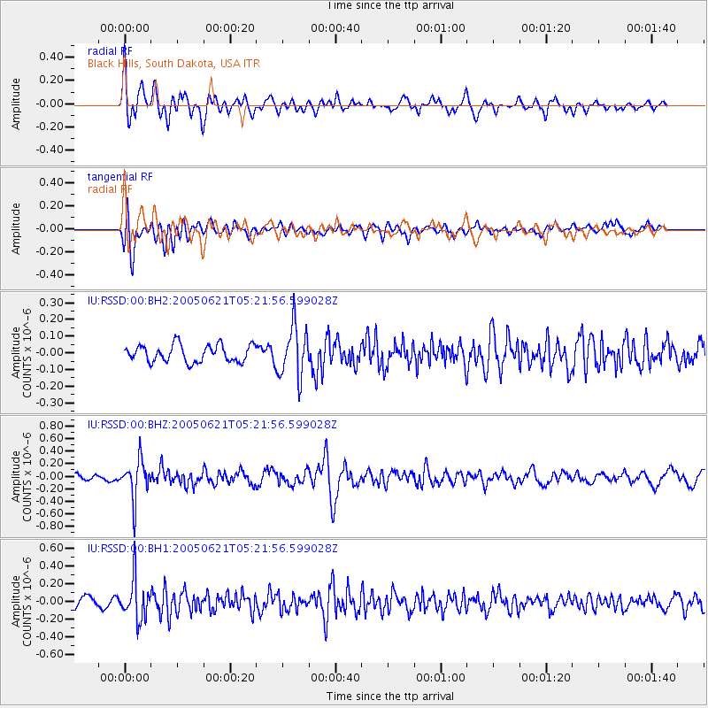
RSSD Black Hills, South Dakota, USA - Earthquake Result Viewer
*The percent match for this event was below the threshold and hence no stack was calculated.
| Earthquake location: |
Chile-Bolivia Border Region |
| Earthquake latitude/longitude: |
-20.0/-68.8 |
| Earthquake time(UTC): |
2005/06/21 (172) 05:11:18 GMT |
| Earthquake Depth: |
105 km |
| Earthquake Magnitude: |
5.4 MB, 5.6 MW, 5.5 MW |
| Earthquake Catalog/Contributor: |
WHDF/NEIC |
|
| Network: |
IU Global Seismograph Network (GSN - IRIS/USGS) |
| Station: |
RSSD Black Hills, South Dakota, USA |
| Lat/Lon: |
44.12 N/104.04 W |
| Elevation: |
2060 m |
|
| Distance: |
71.5 deg |
| Az: |
334.015 deg |
| Baz: |
145.099 deg |
| Ray Param: |
$rayparam |
*The percent match for this event was below the threshold and hence was not used in the summary stack. |
|
| Radial Match: |
74.47114 % |
| Radial Bump: |
400 |
| Transverse Match: |
65.58613 % |
| Transverse Bump: |
400 |
| SOD ConfigId: |
590571 |
| Insert Time: |
2013-09-25 13:46:49.773 +0000 |
| GWidth: |
2.5 |
| Max Bumps: |
400 |
| Tol: |
0.001 |
|
Signal To Noise
| Channel | StoN | STA | LTA |
| IU:RSSD:00:BHZ:20050621T05:21:56.599028Z | 3.8660388 | 3.1355256E-7 | 8.1104346E-8 |
| IU:RSSD:00:BH1:20050621T05:21:56.599028Z | 3.6112463 | 2.2753584E-7 | 6.300756E-8 |
| IU:RSSD:00:BH2:20050621T05:21:56.599028Z | 3.0362964 | 1.547103E-7 | 5.095362E-8 |
| Arrivals |
| Ps | |
| PpPs | |
| PsPs/PpSs | |


