You are here: Home > Network List > II - Global Seismograph Network (GSN - IRIS/IDA) Stations List
> Station MBAR Mbarara, Uganda > Earthquake Result Viewer
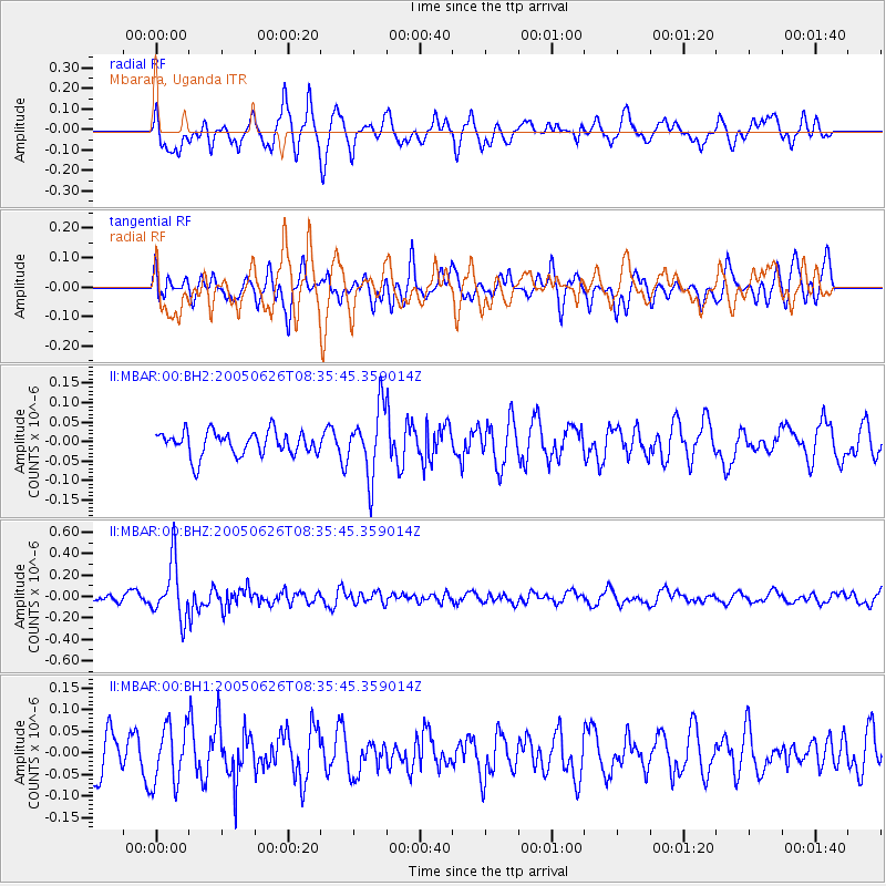
MBAR Mbarara, Uganda - Earthquake Result Viewer
*The percent match for this event was below the threshold and hence no stack was calculated.
| Earthquake location: |
Northern Molucca Sea |
| Earthquake latitude/longitude: |
1.8/125.8 |
| Earthquake time(UTC): |
2005/06/26 (177) 08:23:03 GMT |
| Earthquake Depth: |
92 km |
| Earthquake Magnitude: |
6.0 MB, 5.7 MW, 5.7 MW |
| Earthquake Catalog/Contributor: |
WHDF/NEIC |
|
| Network: |
II Global Seismograph Network (GSN - IRIS/IDA) |
| Station: |
MBAR Mbarara, Uganda |
| Lat/Lon: |
0.60 S/30.74 E |
| Elevation: |
1390 m |
|
| Distance: |
95.1 deg |
| Az: |
269.556 deg |
| Baz: |
88.289 deg |
| Ray Param: |
$rayparam |
*The percent match for this event was below the threshold and hence was not used in the summary stack. |
|
| Radial Match: |
68.94132 % |
| Radial Bump: |
400 |
| Transverse Match: |
55.20235 % |
| Transverse Bump: |
400 |
| SOD ConfigId: |
590571 |
| Insert Time: |
2013-09-25 13:51:07.841 +0000 |
| GWidth: |
2.5 |
| Max Bumps: |
400 |
| Tol: |
0.001 |
|
Signal To Noise
| Channel | StoN | STA | LTA |
| II:MBAR:00:BHZ:20050626T08:35:45.359014Z | 6.4617987 | 2.6281833E-7 | 4.0672628E-8 |
| II:MBAR:00:BH1:20050626T08:35:45.359014Z | 1.6549193 | 6.718072E-8 | 4.059456E-8 |
| II:MBAR:00:BH2:20050626T08:35:45.359014Z | 2.797563 | 8.660624E-8 | 3.0957743E-8 |
| Arrivals |
| Ps | |
| PpPs | |
| PsPs/PpSs | |


