You are here: Home > Network List > N4 - Central and EAstern US Network Stations List
> Station P38B Dawn, MO, USA > Earthquake Result Viewer
P38B Dawn, MO, USA - Earthquake Result Viewer
| Earthquake location: |
Near Coast Of Ecuador |
| Earthquake latitude/longitude: |
-2.0/-80.8 |
| Earthquake time(UTC): |
2019/03/31 (090) 07:04:04 GMT |
| Earthquake Depth: |
19 km |
| Earthquake Magnitude: |
6.2 Mww |
| Earthquake Catalog/Contributor: |
NEIC PDE/us |
|
| Network: |
N4 Central and EAstern US Network |
| Station: |
P38B Dawn, MO, USA |
| Lat/Lon: |
39.62 N/93.53 W |
| Elevation: |
248 m |
|
| Distance: |
43.0 deg |
| Az: |
345.563 deg |
| Baz: |
161.179 deg |
| Ray Param: |
0.07279447 |
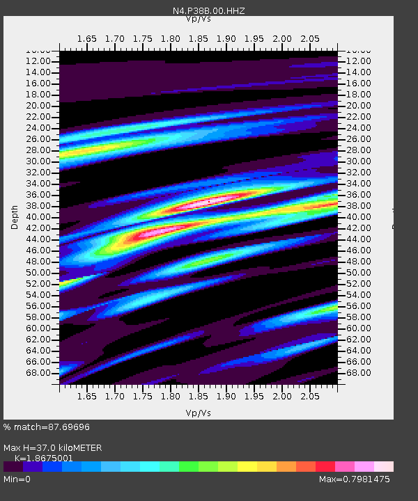
| Estimated Moho Depth: |
37.0 km |
| Estimated Crust Vp/Vs: |
1.87 |
| Assumed Crust Vp: |
6.498 km/s |
| Estimated Crust Vs: |
3.479 km/s |
| Estimated Crust Poisson's Ratio: |
0.30 |
|
| Radial Match: |
87.69696 % |
| Radial Bump: |
312 |
| Transverse Match: |
58.43903 % |
| Transverse Bump: |
400 |
| SOD ConfigId: |
3426611 |
| Insert Time: |
2019-04-14 07:14:11.446 +0000 |
| GWidth: |
2.5 |
| Max Bumps: |
400 |
| Tol: |
0.001 |
|

Signal To Noise
| Channel | StoN | STA | LTA |
| N4:P38B:00:HHZ:20190331T07:11:32.430Z | 5.2380953 | 9.0373436E-7 | 1.725311E-7 |
| N4:P38B:00:HH1:20190331T07:11:32.430Z | 6.9561844 | 5.3477424E-7 | 7.687753E-8 |
| N4:P38B:00:HH2:20190331T07:11:32.430Z | 2.0067594 | 2.2228866E-7 | 1.1076996E-7 |
| Arrivals |
| Ps | 5.3 SECOND |
| PpPs | 15 SECOND |
| PsPs/PpSs | 21 SECOND |


