You are here: Home > Network List > IU - Global Seismograph Network (GSN - IRIS/USGS) Stations List
> Station RSSD Black Hills, South Dakota, USA > Earthquake Result Viewer
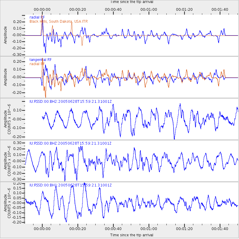
RSSD Black Hills, South Dakota, USA - Earthquake Result Viewer
*The percent match for this event was below the threshold and hence no stack was calculated.
| Earthquake location: |
South Of Fiji Islands |
| Earthquake latitude/longitude: |
-26.9/-176.3 |
| Earthquake time(UTC): |
2005/06/28 (179) 15:46:25 GMT |
| Earthquake Depth: |
31 km |
| Earthquake Magnitude: |
5.4 MB, 5.6 MS, 5.8 MW |
| Earthquake Catalog/Contributor: |
WHDF/NEIC |
|
| Network: |
IU Global Seismograph Network (GSN - IRIS/USGS) |
| Station: |
RSSD Black Hills, South Dakota, USA |
| Lat/Lon: |
44.12 N/104.04 W |
| Elevation: |
2060 m |
|
| Distance: |
96.7 deg |
| Az: |
43.681 deg |
| Baz: |
238.886 deg |
| Ray Param: |
$rayparam |
*The percent match for this event was below the threshold and hence was not used in the summary stack. |
|
| Radial Match: |
77.54178 % |
| Radial Bump: |
400 |
| Transverse Match: |
80.02849 % |
| Transverse Bump: |
324 |
| SOD ConfigId: |
590571 |
| Insert Time: |
2013-09-25 13:53:11.780 +0000 |
| GWidth: |
2.5 |
| Max Bumps: |
400 |
| Tol: |
0.001 |
|
Signal To Noise
| Channel | StoN | STA | LTA |
| IU:RSSD:00:BHZ:20050628T15:59:21.31001Z | 1.8049208 | 1.4523351E-7 | 8.046531E-8 |
| IU:RSSD:00:BH1:20050628T15:59:21.31001Z | 1.8226689 | 6.848515E-8 | 3.75741E-8 |
| IU:RSSD:00:BH2:20050628T15:59:21.31001Z | 1.2407925 | 8.006599E-8 | 6.45281E-8 |
| Arrivals |
| Ps | |
| PpPs | |
| PsPs/PpSs | |


