You are here: Home > Network List > IU - Global Seismograph Network (GSN - IRIS/USGS) Stations List
> Station RSSD Black Hills, South Dakota, USA > Earthquake Result Viewer
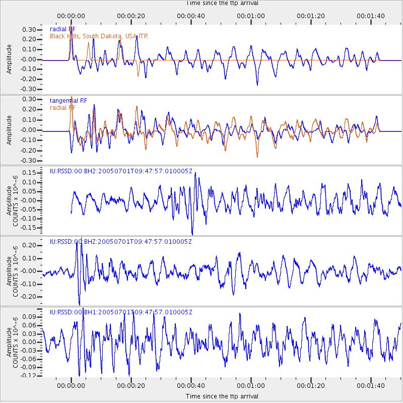
RSSD Black Hills, South Dakota, USA - Earthquake Result Viewer
*The percent match for this event was below the threshold and hence no stack was calculated.
| Earthquake location: |
Southeast Of Honshu, Japan |
| Earthquake latitude/longitude: |
31.9/139.1 |
| Earthquake time(UTC): |
2005/07/01 (182) 09:36:16 GMT |
| Earthquake Depth: |
206 km |
| Earthquake Magnitude: |
5.5 MW, 5.5 MW |
| Earthquake Catalog/Contributor: |
NEIC PDE/NEIC PDE-M |
|
| Network: |
IU Global Seismograph Network (GSN - IRIS/USGS) |
| Station: |
RSSD Black Hills, South Dakota, USA |
| Lat/Lon: |
44.12 N/104.04 W |
| Elevation: |
2060 m |
|
| Distance: |
85.0 deg |
| Az: |
40.146 deg |
| Baz: |
310.426 deg |
| Ray Param: |
$rayparam |
*The percent match for this event was below the threshold and hence was not used in the summary stack. |
|
| Radial Match: |
50.42724 % |
| Radial Bump: |
400 |
| Transverse Match: |
54.66763 % |
| Transverse Bump: |
400 |
| SOD ConfigId: |
590571 |
| Insert Time: |
2013-09-25 13:57:09.059 +0000 |
| GWidth: |
2.5 |
| Max Bumps: |
400 |
| Tol: |
0.001 |
|
Signal To Noise
| Channel | StoN | STA | LTA |
| IU:RSSD:00:BHZ:20050701T09:47:57.010005Z | 3.4221935 | 1.2359305E-7 | 3.6115157E-8 |
| IU:RSSD:00:BH1:20050701T09:47:57.010005Z | 1.3968341 | 6.362979E-8 | 4.5552863E-8 |
| IU:RSSD:00:BH2:20050701T09:47:57.010005Z | 1.5309619 | 4.7889557E-8 | 3.12807E-8 |
| Arrivals |
| Ps | |
| PpPs | |
| PsPs/PpSs | |


