You are here: Home > Network List > N4 - Central and EAstern US Network Stations List
> Station V61A Roper, NC, USA > Earthquake Result Viewer
V61A Roper, NC, USA - Earthquake Result Viewer
| Earthquake location: |
Near Coast Of Ecuador |
| Earthquake latitude/longitude: |
-2.0/-80.8 |
| Earthquake time(UTC): |
2019/03/31 (090) 07:04:04 GMT |
| Earthquake Depth: |
19 km |
| Earthquake Magnitude: |
6.2 Mww |
| Earthquake Catalog/Contributor: |
NEIC PDE/us |
|
| Network: |
N4 Central and EAstern US Network |
| Station: |
V61A Roper, NC, USA |
| Lat/Lon: |
35.79 N/76.58 W |
| Elevation: |
4.0 m |
|
| Distance: |
37.8 deg |
| Az: |
5.617 deg |
| Baz: |
186.91 deg |
| Ray Param: |
0.07591585 |
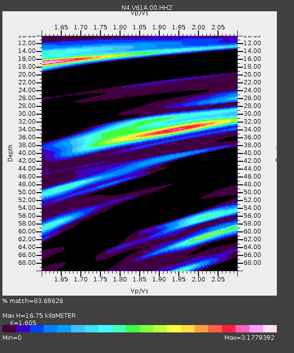
| Estimated Moho Depth: |
16.75 km |
| Estimated Crust Vp/Vs: |
1.61 |
| Assumed Crust Vp: |
6.565 km/s |
| Estimated Crust Vs: |
4.09 km/s |
| Estimated Crust Poisson's Ratio: |
0.18 |
|
| Radial Match: |
83.69626 % |
| Radial Bump: |
297 |
| Transverse Match: |
57.234383 % |
| Transverse Bump: |
374 |
| SOD ConfigId: |
3426611 |
| Insert Time: |
2019-04-14 07:15:21.293 +0000 |
| GWidth: |
2.5 |
| Max Bumps: |
400 |
| Tol: |
0.001 |
|

Signal To Noise
| Channel | StoN | STA | LTA |
| N4:V61A:00:HHZ:20190331T07:10:49.16999Z | 3.1399374 | 1.5376795E-6 | 4.897166E-7 |
| N4:V61A:00:HH1:20190331T07:10:49.16999Z | 1.879999 | 1.5926986E-6 | 8.4718056E-7 |
| N4:V61A:00:HH2:20190331T07:10:49.16999Z | 1.6993978 | 9.596856E-7 | 5.6472095E-7 |
| Arrivals |
| Ps | 1.7 SECOND |
| PpPs | 6.1 SECOND |
| PsPs/PpSs | 7.8 SECOND |


