You are here: Home > Network List > IU - Global Seismograph Network (GSN - IRIS/USGS) Stations List
> Station RSSD Black Hills, South Dakota, USA > Earthquake Result Viewer
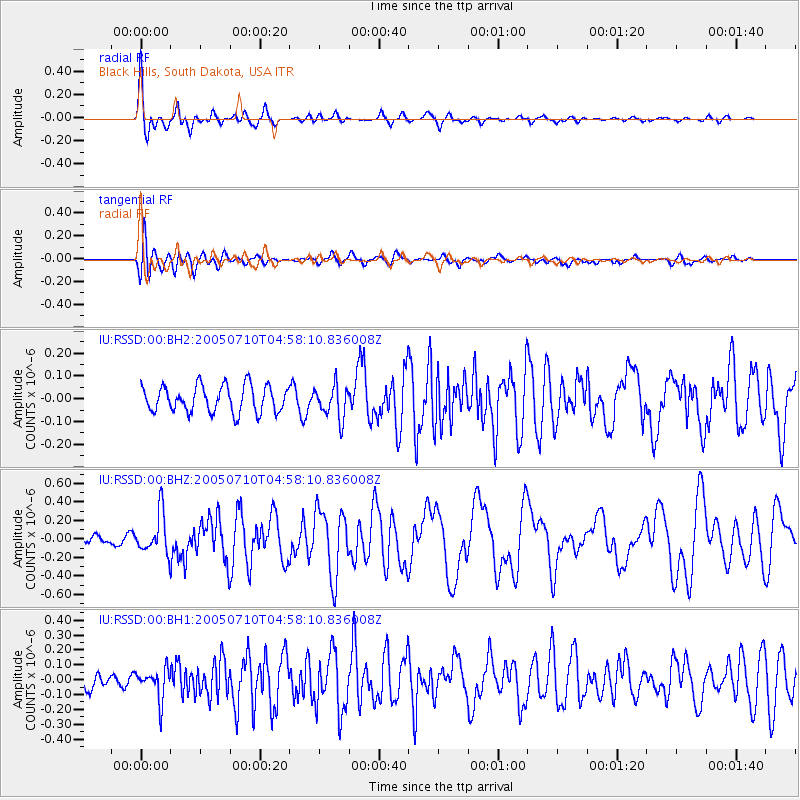
RSSD Black Hills, South Dakota, USA - Earthquake Result Viewer
*The percent match for this event was below the threshold and hence no stack was calculated.
| Earthquake location: |
West Chile Rise |
| Earthquake latitude/longitude: |
-36.3/-97.3 |
| Earthquake time(UTC): |
2005/07/10 (191) 04:46:31 GMT |
| Earthquake Depth: |
10 km |
| Earthquake Magnitude: |
5.3 MB, 5.7 MS, 6.1 MW, 6.0 MW |
| Earthquake Catalog/Contributor: |
WHDF/NEIC |
|
| Network: |
IU Global Seismograph Network (GSN - IRIS/USGS) |
| Station: |
RSSD Black Hills, South Dakota, USA |
| Lat/Lon: |
44.12 N/104.04 W |
| Elevation: |
2060 m |
|
| Distance: |
80.3 deg |
| Az: |
355.057 deg |
| Baz: |
174.455 deg |
| Ray Param: |
$rayparam |
*The percent match for this event was below the threshold and hence was not used in the summary stack. |
|
| Radial Match: |
89.11014 % |
| Radial Bump: |
375 |
| Transverse Match: |
62.03127 % |
| Transverse Bump: |
400 |
| SOD ConfigId: |
590571 |
| Insert Time: |
2013-09-25 14:09:18.235 +0000 |
| GWidth: |
2.5 |
| Max Bumps: |
400 |
| Tol: |
0.001 |
|
Signal To Noise
| Channel | StoN | STA | LTA |
| IU:RSSD:00:BHZ:20050710T04:58:10.836008Z | 5.633762 | 2.2011544E-7 | 3.9070773E-8 |
| IU:RSSD:00:BH1:20050710T04:58:10.836008Z | 1.5421356 | 1.01724034E-7 | 6.596309E-8 |
| IU:RSSD:00:BH2:20050710T04:58:10.836008Z | 1.2314159 | 7.184758E-8 | 5.8345503E-8 |
| Arrivals |
| Ps | |
| PpPs | |
| PsPs/PpSs | |


