You are here: Home > Network List > IU - Global Seismograph Network (GSN - IRIS/USGS) Stations List
> Station RSSD Black Hills, South Dakota, USA > Earthquake Result Viewer
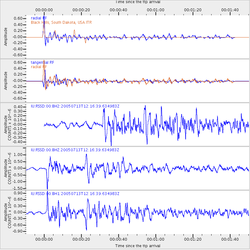
RSSD Black Hills, South Dakota, USA - Earthquake Result Viewer
*The percent match for this event was below the threshold and hence no stack was calculated.
| Earthquake location: |
Near Coast Of Peru |
| Earthquake latitude/longitude: |
-17.8/-70.1 |
| Earthquake time(UTC): |
2005/07/13 (194) 12:06:13 GMT |
| Earthquake Depth: |
80 km |
| Earthquake Magnitude: |
5.6 MB, 5.9 MW, 5.8 MW |
| Earthquake Catalog/Contributor: |
WHDF/NEIC |
|
| Network: |
IU Global Seismograph Network (GSN - IRIS/USGS) |
| Station: |
RSSD Black Hills, South Dakota, USA |
| Lat/Lon: |
44.12 N/104.04 W |
| Elevation: |
2060 m |
|
| Distance: |
69.0 deg |
| Az: |
334.502 deg |
| Baz: |
145.297 deg |
| Ray Param: |
$rayparam |
*The percent match for this event was below the threshold and hence was not used in the summary stack. |
|
| Radial Match: |
90.39354 % |
| Radial Bump: |
400 |
| Transverse Match: |
83.97815 % |
| Transverse Bump: |
400 |
| SOD ConfigId: |
590571 |
| Insert Time: |
2013-09-25 14:16:21.515 +0000 |
| GWidth: |
2.5 |
| Max Bumps: |
400 |
| Tol: |
0.001 |
|
Signal To Noise
| Channel | StoN | STA | LTA |
| IU:RSSD:00:BHZ:20050713T12:16:39.634983Z | 8.03801 | 5.098907E-7 | 6.3434946E-8 |
| IU:RSSD:00:BH1:20050713T12:16:39.634983Z | 7.139133 | 3.0436766E-7 | 4.26337E-8 |
| IU:RSSD:00:BH2:20050713T12:16:39.634983Z | 4.4504066 | 1.7480951E-7 | 3.927945E-8 |
| Arrivals |
| Ps | |
| PpPs | |
| PsPs/PpSs | |


