You are here: Home > Network List > YT07 - POLENET Stations List
> Station MILR MILR > Earthquake Result Viewer
MILR MILR - Earthquake Result Viewer
| Earthquake location: |
New Britain Region, P.N.G. |
| Earthquake latitude/longitude: |
-6.0/149.5 |
| Earthquake time(UTC): |
2014/10/01 (274) 03:38:54 GMT |
| Earthquake Depth: |
58 km |
| Earthquake Magnitude: |
5.7 MB |
| Earthquake Catalog/Contributor: |
NEIC PDE/NEIC COMCAT |
|
| Network: |
YT POLENET |
| Station: |
MILR MILR |
| Lat/Lon: |
83.31 S/156.25 E |
| Elevation: |
1901 m |
|
| Distance: |
77.3 deg |
| Az: |
179.188 deg |
| Baz: |
353.103 deg |
| Ray Param: |
0.050296616 |
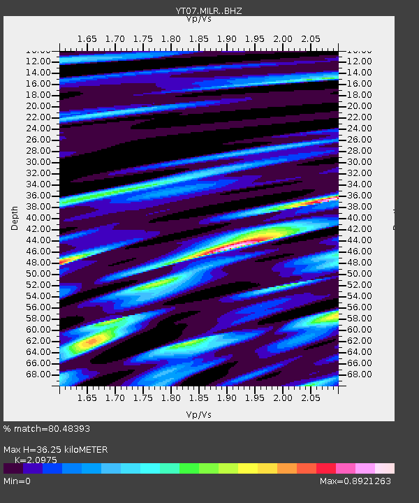
| Estimated Moho Depth: |
36.25 km |
| Estimated Crust Vp/Vs: |
2.10 |
| Assumed Crust Vp: |
6.371 km/s |
| Estimated Crust Vs: |
3.038 km/s |
| Estimated Crust Poisson's Ratio: |
0.35 |
|
| Radial Match: |
80.48393 % |
| Radial Bump: |
400 |
| Transverse Match: |
77.65467 % |
| Transverse Bump: |
400 |
| SOD ConfigId: |
3390531 |
| Insert Time: |
2019-04-14 07:16:06.031 +0000 |
| GWidth: |
2.5 |
| Max Bumps: |
400 |
| Tol: |
0.001 |
|

Signal To Noise
| Channel | StoN | STA | LTA |
| YT:MILR: :BHZ:20141001T03:50:10.650012Z | 8.096691 | 5.692219E-7 | 7.030303E-8 |
| YT:MILR: :BHN:20141001T03:50:10.650012Z | 4.3426304 | 2.8146908E-7 | 6.4815346E-8 |
| YT:MILR: :BHE:20141001T03:50:10.650012Z | 2.7491834 | 1.0648664E-7 | 3.8733916E-8 |
| Arrivals |
| Ps | 6.4 SECOND |
| PpPs | 17 SECOND |
| PsPs/PpSs | 24 SECOND |


