You are here: Home > Network List > NM - Cooperative New Madrid Seismic Network Stations List
> Station FFIL Fairfield, IL > Earthquake Result Viewer
FFIL Fairfield, IL - Earthquake Result Viewer
| Earthquake location: |
Near Coast Of Ecuador |
| Earthquake latitude/longitude: |
-2.0/-80.8 |
| Earthquake time(UTC): |
2019/03/31 (090) 07:04:04 GMT |
| Earthquake Depth: |
19 km |
| Earthquake Magnitude: |
6.2 Mww |
| Earthquake Catalog/Contributor: |
NEIC PDE/us |
|
| Network: |
NM Cooperative New Madrid Seismic Network |
| Station: |
FFIL Fairfield, IL |
| Lat/Lon: |
38.38 N/88.39 W |
| Elevation: |
446 m |
|
| Distance: |
40.8 deg |
| Az: |
350.864 deg |
| Baz: |
168.351 deg |
| Ray Param: |
0.074181266 |
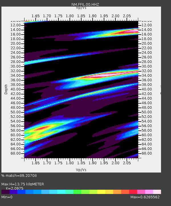
| Estimated Moho Depth: |
13.75 km |
| Estimated Crust Vp/Vs: |
2.10 |
| Assumed Crust Vp: |
6.444 km/s |
| Estimated Crust Vs: |
3.072 km/s |
| Estimated Crust Poisson's Ratio: |
0.35 |
|
| Radial Match: |
89.20708 % |
| Radial Bump: |
280 |
| Transverse Match: |
62.22108 % |
| Transverse Bump: |
400 |
| SOD ConfigId: |
3426611 |
| Insert Time: |
2019-04-14 07:16:32.864 +0000 |
| GWidth: |
2.5 |
| Max Bumps: |
400 |
| Tol: |
0.001 |
|

Signal To Noise
| Channel | StoN | STA | LTA |
| NM:FFIL:00:HHZ:20190331T07:11:14.048988Z | 7.2370963 | 1.1870532E-6 | 1.640234E-7 |
| NM:FFIL:00:HHN:20190331T07:11:14.048988Z | 5.989927 | 6.975221E-7 | 1.16449186E-7 |
| NM:FFIL:00:HHE:20190331T07:11:14.048988Z | 0.9823744 | 1.11256966E-7 | 1.1325312E-7 |
| Arrivals |
| Ps | 2.5 SECOND |
| PpPs | 6.2 SECOND |
| PsPs/PpSs | 8.7 SECOND |


