You are here: Home > Network List > IU - Global Seismograph Network (GSN - IRIS/USGS) Stations List
> Station RSSD Black Hills, South Dakota, USA > Earthquake Result Viewer
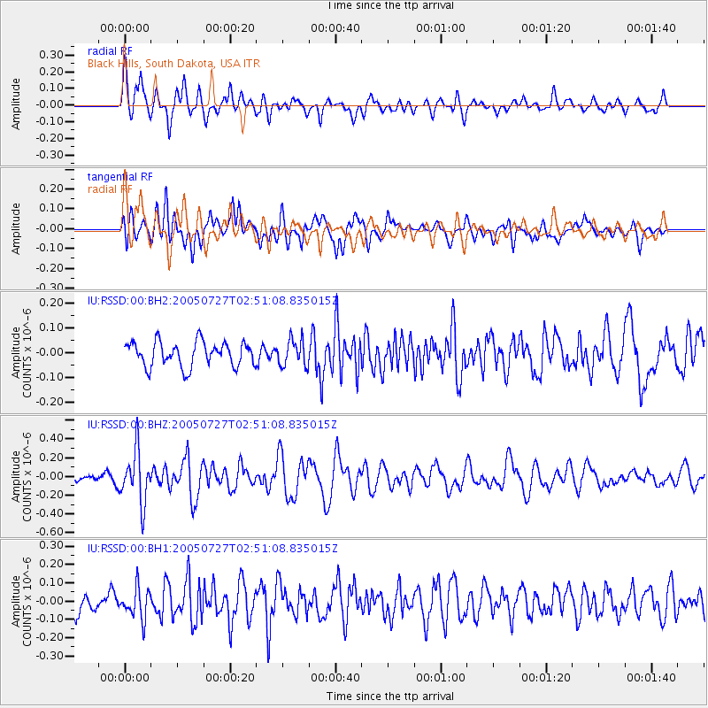
RSSD Black Hills, South Dakota, USA - Earthquake Result Viewer
*The percent match for this event was below the threshold and hence no stack was calculated.
| Earthquake location: |
Off East Coast Of Honshu, Japan |
| Earthquake latitude/longitude: |
33.3/142.3 |
| Earthquake time(UTC): |
2005/07/27 (208) 02:39:22 GMT |
| Earthquake Depth: |
34 km |
| Earthquake Magnitude: |
5.5 MB, 4.8 MS, 5.3 MW |
| Earthquake Catalog/Contributor: |
WHDF/NEIC |
|
| Network: |
IU Global Seismograph Network (GSN - IRIS/USGS) |
| Station: |
RSSD Black Hills, South Dakota, USA |
| Lat/Lon: |
44.12 N/104.04 W |
| Elevation: |
2060 m |
|
| Distance: |
82.1 deg |
| Az: |
41.757 deg |
| Baz: |
309.212 deg |
| Ray Param: |
$rayparam |
*The percent match for this event was below the threshold and hence was not used in the summary stack. |
|
| Radial Match: |
68.95188 % |
| Radial Bump: |
400 |
| Transverse Match: |
63.618736 % |
| Transverse Bump: |
400 |
| SOD ConfigId: |
590571 |
| Insert Time: |
2013-09-25 14:35:13.300 +0000 |
| GWidth: |
2.5 |
| Max Bumps: |
400 |
| Tol: |
0.001 |
|
Signal To Noise
| Channel | StoN | STA | LTA |
| IU:RSSD:00:BHZ:20050727T02:51:08.835015Z | 4.449857 | 2.793534E-7 | 6.277806E-8 |
| IU:RSSD:00:BH1:20050727T02:51:08.835015Z | 1.5818056 | 8.4934854E-8 | 5.369488E-8 |
| IU:RSSD:00:BH2:20050727T02:51:08.835015Z | 1.0825678 | 5.3197812E-8 | 4.9140397E-8 |
| Arrivals |
| Ps | |
| PpPs | |
| PsPs/PpSs | |


