You are here: Home > Network List > TX - Texas Seismological Network Stations List
> Station FW13 Cleburne > Earthquake Result Viewer
FW13 Cleburne - Earthquake Result Viewer
| Earthquake location: |
Near Coast Of Ecuador |
| Earthquake latitude/longitude: |
-2.0/-80.8 |
| Earthquake time(UTC): |
2019/03/31 (090) 07:04:04 GMT |
| Earthquake Depth: |
19 km |
| Earthquake Magnitude: |
6.2 Mww |
| Earthquake Catalog/Contributor: |
NEIC PDE/us |
|
| Network: |
TX Texas Seismological Network |
| Station: |
FW13 Cleburne |
| Lat/Lon: |
32.35 N/97.43 W |
| Elevation: |
259 m |
|
| Distance: |
37.6 deg |
| Az: |
336.623 deg |
| Baz: |
152.063 deg |
| Ray Param: |
0.076021425 |
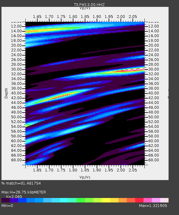
| Estimated Moho Depth: |
29.75 km |
| Estimated Crust Vp/Vs: |
2.07 |
| Assumed Crust Vp: |
6.38 km/s |
| Estimated Crust Vs: |
3.09 km/s |
| Estimated Crust Poisson's Ratio: |
0.35 |
|
| Radial Match: |
81.461754 % |
| Radial Bump: |
381 |
| Transverse Match: |
71.15341 % |
| Transverse Bump: |
400 |
| SOD ConfigId: |
3426611 |
| Insert Time: |
2019-04-14 07:18:29.971 +0000 |
| GWidth: |
2.5 |
| Max Bumps: |
400 |
| Tol: |
0.001 |
|

Signal To Noise
| Channel | StoN | STA | LTA |
| TX:FW13:00:HHZ:20190331T07:10:47.630012Z | 5.2146716 | 8.078507E-7 | 1.549188E-7 |
| TX:FW13:00:HH1:20190331T07:10:47.630012Z | 1.8227502 | 2.6475783E-7 | 1.4525185E-7 |
| TX:FW13:00:HH2:20190331T07:10:47.630012Z | 1.9031729 | 3.2299798E-7 | 1.6971552E-7 |
| Arrivals |
| Ps | 5.3 SECOND |
| PpPs | 13 SECOND |
| PsPs/PpSs | 19 SECOND |


