You are here: Home > Network List > CI - Caltech Regional Seismic Network Stations List
> Station TIN Tinemaha, Big Pine, CA, USA > Earthquake Result Viewer
TIN Tinemaha, Big Pine, CA, USA - Earthquake Result Viewer
| Earthquake location: |
Tonga Islands Region |
| Earthquake latitude/longitude: |
-23.0/-174.7 |
| Earthquake time(UTC): |
2009/03/19 (078) 18:17:40 GMT |
| Earthquake Depth: |
34 km |
| Earthquake Magnitude: |
7.0 MB, 7.6 MS, 7.6 MW, 7.6 MW |
| Earthquake Catalog/Contributor: |
WHDF/NEIC |
|
| Network: |
CI Caltech Regional Seismic Network |
| Station: |
TIN Tinemaha, Big Pine, CA, USA |
| Lat/Lon: |
37.05 N/118.23 W |
| Elevation: |
1197 m |
|
| Distance: |
80.0 deg |
| Az: |
42.601 deg |
| Baz: |
231.203 deg |
| Ray Param: |
0.04854074 |
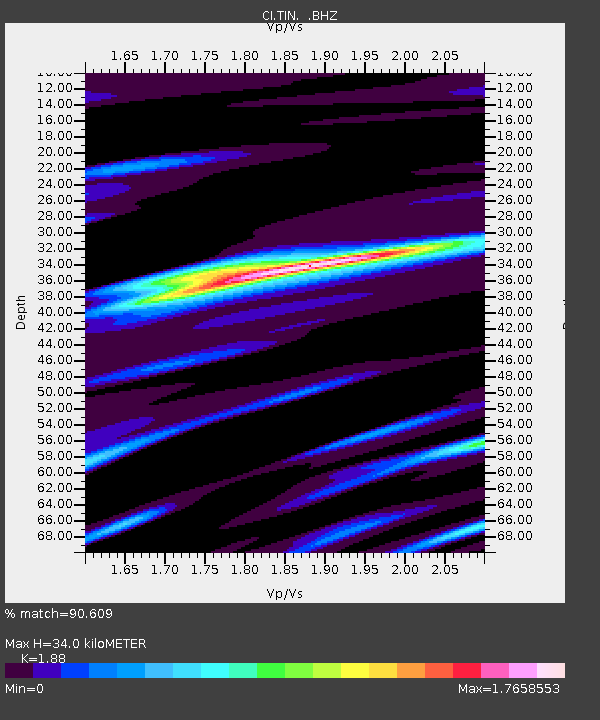
| Estimated Moho Depth: |
34.0 km |
| Estimated Crust Vp/Vs: |
1.88 |
| Assumed Crust Vp: |
6.291 km/s |
| Estimated Crust Vs: |
3.346 km/s |
| Estimated Crust Poisson's Ratio: |
0.30 |
|
| Radial Match: |
90.609 % |
| Radial Bump: |
400 |
| Transverse Match: |
80.36666 % |
| Transverse Bump: |
400 |
| SOD ConfigId: |
2658 |
| Insert Time: |
2010-02-25 20:44:34.865 +0000 |
| GWidth: |
2.5 |
| Max Bumps: |
400 |
| Tol: |
0.001 |
|
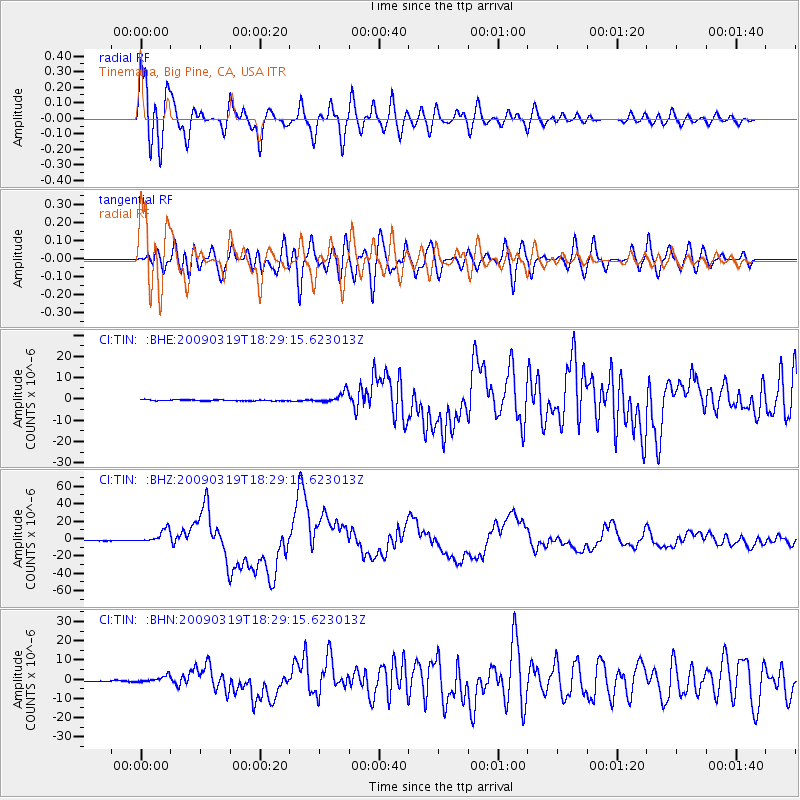
Signal To Noise
| Channel | StoN | STA | LTA |
| CI:TIN: :BHZ:20090319T18:29:15.623013Z | 19.82657 | 7.609053E-6 | 3.8378056E-7 |
| CI:TIN: :BHN:20090319T18:29:15.623013Z | 11.9945755 | 1.741104E-6 | 1.4515763E-7 |
| CI:TIN: :BHE:20090319T18:29:15.623013Z | 10.246022 | 2.5456939E-6 | 2.484568E-7 |
| Arrivals |
| Ps | 4.9 SECOND |
| PpPs | 15 SECOND |
| PsPs/PpSs | 20 SECOND |


