You are here: Home > Network List > IU - Global Seismograph Network (GSN - IRIS/USGS) Stations List
> Station RSSD Black Hills, South Dakota, USA > Earthquake Result Viewer
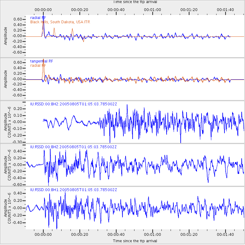
RSSD Black Hills, South Dakota, USA - Earthquake Result Viewer
*The percent match for this event was below the threshold and hence no stack was calculated.
| Earthquake location: |
Andreanof Islands, Aleutian Is. |
| Earthquake latitude/longitude: |
51.2/-178.3 |
| Earthquake time(UTC): |
2005/08/05 (217) 00:56:53 GMT |
| Earthquake Depth: |
23 km |
| Earthquake Magnitude: |
5.6 MB, 5.3 MS, 5.8 MW, 5.7 MW |
| Earthquake Catalog/Contributor: |
WHDF/NEIC |
|
| Network: |
IU Global Seismograph Network (GSN - IRIS/USGS) |
| Station: |
RSSD Black Hills, South Dakota, USA |
| Lat/Lon: |
44.12 N/104.04 W |
| Elevation: |
2060 m |
|
| Distance: |
48.5 deg |
| Az: |
67.73 deg |
| Baz: |
306.118 deg |
| Ray Param: |
$rayparam |
*The percent match for this event was below the threshold and hence was not used in the summary stack. |
|
| Radial Match: |
79.6784 % |
| Radial Bump: |
400 |
| Transverse Match: |
62.958405 % |
| Transverse Bump: |
400 |
| SOD ConfigId: |
590571 |
| Insert Time: |
2013-09-25 14:46:54.034 +0000 |
| GWidth: |
2.5 |
| Max Bumps: |
400 |
| Tol: |
0.001 |
|
Signal To Noise
| Channel | StoN | STA | LTA |
| IU:RSSD:00:BHZ:20050805T01:05:03.785002Z | 4.061659 | 2.3243095E-7 | 5.7225616E-8 |
| IU:RSSD:00:BH1:20050805T01:05:03.785002Z | 3.574594 | 1.742696E-7 | 4.875228E-8 |
| IU:RSSD:00:BH2:20050805T01:05:03.785002Z | 1.316332 | 5.888789E-8 | 4.473635E-8 |
| Arrivals |
| Ps | |
| PpPs | |
| PsPs/PpSs | |


