You are here: Home > Network List > IU - Global Seismograph Network (GSN - IRIS/USGS) Stations List
> Station RSSD Black Hills, South Dakota, USA > Earthquake Result Viewer
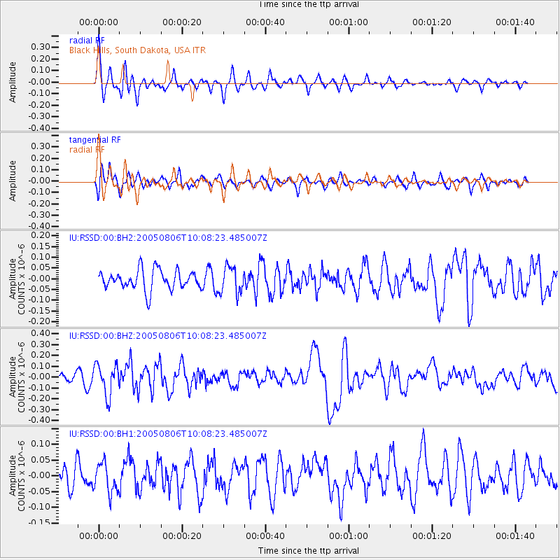
RSSD Black Hills, South Dakota, USA - Earthquake Result Viewer
*The percent match for this event was below the threshold and hence no stack was calculated.
| Earthquake location: |
Tonga Islands |
| Earthquake latitude/longitude: |
-19.6/-175.9 |
| Earthquake time(UTC): |
2005/08/06 (218) 09:56:13 GMT |
| Earthquake Depth: |
205 km |
| Earthquake Magnitude: |
5.3 MB, 6.0 MW, 6.0 MW |
| Earthquake Catalog/Contributor: |
WHDF/NEIC |
|
| Network: |
IU Global Seismograph Network (GSN - IRIS/USGS) |
| Station: |
RSSD Black Hills, South Dakota, USA |
| Lat/Lon: |
44.12 N/104.04 W |
| Elevation: |
2060 m |
|
| Distance: |
91.1 deg |
| Az: |
43.186 deg |
| Baz: |
243.607 deg |
| Ray Param: |
$rayparam |
*The percent match for this event was below the threshold and hence was not used in the summary stack. |
|
| Radial Match: |
73.37582 % |
| Radial Bump: |
391 |
| Transverse Match: |
60.782257 % |
| Transverse Bump: |
400 |
| SOD ConfigId: |
590571 |
| Insert Time: |
2013-09-25 14:49:08.665 +0000 |
| GWidth: |
2.5 |
| Max Bumps: |
400 |
| Tol: |
0.001 |
|
Signal To Noise
| Channel | StoN | STA | LTA |
| IU:RSSD:00:BHZ:20050806T10:08:23.485007Z | 2.7025037 | 1.4504525E-7 | 5.3670693E-8 |
| IU:RSSD:00:BH1:20050806T10:08:23.485007Z | 0.9058221 | 4.7108223E-8 | 5.2006044E-8 |
| IU:RSSD:00:BH2:20050806T10:08:23.485007Z | 1.3553967 | 6.1955085E-8 | 4.570992E-8 |
| Arrivals |
| Ps | |
| PpPs | |
| PsPs/PpSs | |


