You are here: Home > Network List > US - United States National Seismic Network Stations List
> Station HAWA Hanford, Washington, USA > Earthquake Result Viewer
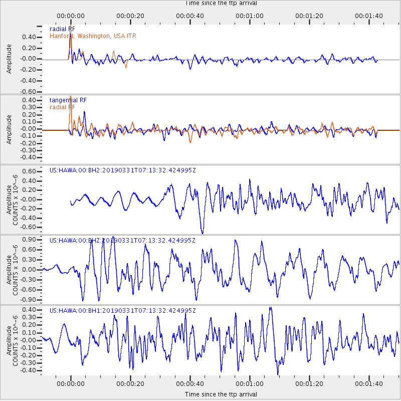
HAWA Hanford, Washington, USA - Earthquake Result Viewer
*The percent match for this event was below the threshold and hence no stack was calculated.
| Earthquake location: |
Near Coast Of Ecuador |
| Earthquake latitude/longitude: |
-2.0/-80.8 |
| Earthquake time(UTC): |
2019/03/31 (090) 07:04:04 GMT |
| Earthquake Depth: |
19 km |
| Earthquake Magnitude: |
6.2 Mww |
| Earthquake Catalog/Contributor: |
NEIC PDE/us |
|
| Network: |
US United States National Seismic Network |
| Station: |
HAWA Hanford, Washington, USA |
| Lat/Lon: |
46.39 N/119.53 W |
| Elevation: |
364 m |
|
| Distance: |
59.0 deg |
| Az: |
329.665 deg |
| Baz: |
133.174 deg |
| Ray Param: |
$rayparam |
*The percent match for this event was below the threshold and hence was not used in the summary stack. |
|
| Radial Match: |
70.63558 % |
| Radial Bump: |
400 |
| Transverse Match: |
68.39883 % |
| Transverse Bump: |
400 |
| SOD ConfigId: |
3426611 |
| Insert Time: |
2019-04-14 07:20:18.614 +0000 |
| GWidth: |
2.5 |
| Max Bumps: |
400 |
| Tol: |
0.001 |
|
Signal To Noise
| Channel | StoN | STA | LTA |
| US:HAWA:00:BHZ:20190331T07:13:32.424995Z | 2.4522116 | 3.6049346E-7 | 1.4700748E-7 |
| US:HAWA:00:BH1:20190331T07:13:32.424995Z | 1.4135851 | 1.2631452E-7 | 8.935756E-8 |
| US:HAWA:00:BH2:20190331T07:13:32.424995Z | 1.8966615 | 1.8224965E-7 | 9.608971E-8 |
| Arrivals |
| Ps | |
| PpPs | |
| PsPs/PpSs | |


