You are here: Home > Network List > IU - Global Seismograph Network (GSN - IRIS/USGS) Stations List
> Station RSSD Black Hills, South Dakota, USA > Earthquake Result Viewer
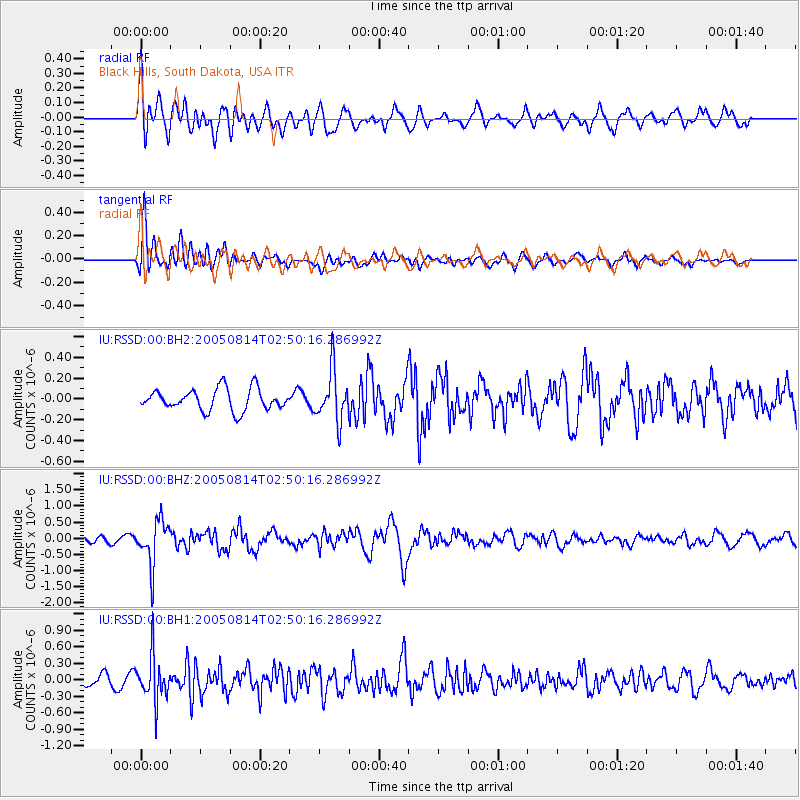
RSSD Black Hills, South Dakota, USA - Earthquake Result Viewer
*The percent match for this event was below the threshold and hence no stack was calculated.
| Earthquake location: |
Chile-Bolivia Border Region |
| Earthquake latitude/longitude: |
-19.8/-69.0 |
| Earthquake time(UTC): |
2005/08/14 (226) 02:39:40 GMT |
| Earthquake Depth: |
114 km |
| Earthquake Magnitude: |
5.7 MB, 5.9 MW, 5.8 MW |
| Earthquake Catalog/Contributor: |
WHDF/NEIC |
|
| Network: |
IU Global Seismograph Network (GSN - IRIS/USGS) |
| Station: |
RSSD Black Hills, South Dakota, USA |
| Lat/Lon: |
44.12 N/104.04 W |
| Elevation: |
2060 m |
|
| Distance: |
71.2 deg |
| Az: |
334.093 deg |
| Baz: |
145.159 deg |
| Ray Param: |
$rayparam |
*The percent match for this event was below the threshold and hence was not used in the summary stack. |
|
| Radial Match: |
70.51013 % |
| Radial Bump: |
400 |
| Transverse Match: |
75.993805 % |
| Transverse Bump: |
400 |
| SOD ConfigId: |
590571 |
| Insert Time: |
2013-09-25 15:04:05.328 +0000 |
| GWidth: |
2.5 |
| Max Bumps: |
400 |
| Tol: |
0.001 |
|
Signal To Noise
| Channel | StoN | STA | LTA |
| IU:RSSD:00:BHZ:20050814T02:50:16.286992Z | 7.618356 | 6.912239E-7 | 9.073137E-8 |
| IU:RSSD:00:BH1:20050814T02:50:16.286992Z | 4.0099673 | 4.0580787E-7 | 1.01199795E-7 |
| IU:RSSD:00:BH2:20050814T02:50:16.286992Z | 2.3703554 | 2.4379042E-7 | 1.0284974E-7 |
| Arrivals |
| Ps | |
| PpPs | |
| PsPs/PpSs | |


