RSSD Black Hills, South Dakota, USA - Earthquake Result Viewer
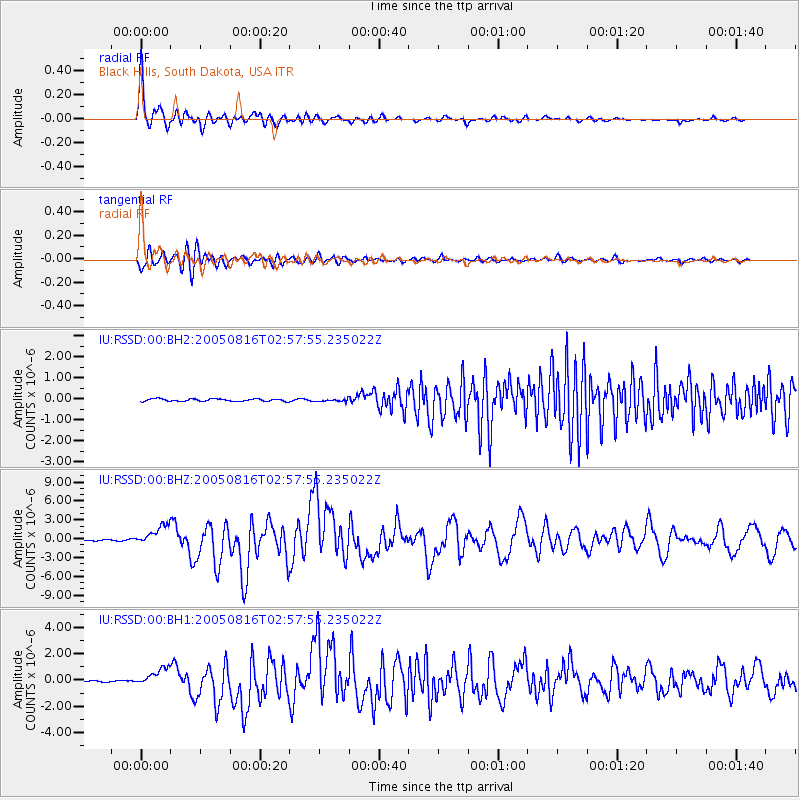
Earthquake location: Near East Coast Of Honshu, Japan
Earthquake latitude/longitude: 38.3/142.0
Earthquake time(UTC): 2005/08/16 (228) 02:46:28 GMT
Earthquake Depth: 36 km
Earthquake Magnitude: 6.5 MB, 6.8 MS, 7.2 MW, 7.1 MW
Earthquake Catalog/Contributor: WHDF/NEIC
Network: IU Global Seismograph Network (GSN - IRIS/USGS)
Station: RSSD Black Hills, South Dakota, USA
Lat/Lon: 44.12 N/104.04 W
Elevation: 2060 m
Distance: 78.6 deg
Az: 42.194 deg
Baz: 312.779 deg
Ray Param: 0.04949601
Estimated Moho Depth: 15.5 km
Estimated Crust Vp/Vs: 2.10
Assumed Crust Vp: 6.242 km/s
Estimated Crust Vs: 2.976 km/s
Estimated Crust Poisson's Ratio: 0.35
Radial Match: 97.469696 %
Radial Bump: 400
Transverse Match: 90.12845 %
Transverse Bump: 400
SOD ConfigId: 590571
Insert Time: 2013-09-25 15:07:14.824 +0000
GWidth: 2.5
Max Bumps: 400
Tol: 0.001

Signal To Noise

ChannelStoNSTALTA
IU:RSSD:00:BHZ:20050816T02:57:55.235022Z25.6451511.6041919E-66.255342E-8
IU:RSSD:00:BH1:20050816T02:57:55.235022Z12.694146.730491E-75.3020454E-8
IU:RSSD:00:BH2:20050816T02:57:55.235022Z1.00075825.7521213E-85.7477635E-8
Arrivals
Ps2.8 SECOND
PpPs7.5 SECOND
PsPs/PpSs10 SECOND