You are here: Home > Network List > YT07 - POLENET Stations List
> Station ALYS ALYS > Earthquake Result Viewer
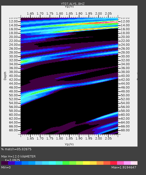
ALYS ALYS - Earthquake Result Viewer
| Earthquake location: |
Tonga Islands |
| Earthquake latitude/longitude: |
-21.1/-174.5 |
| Earthquake time(UTC): |
2014/10/02 (275) 00:13:39 GMT |
| Earthquake Depth: |
10 km |
| Earthquake Magnitude: |
5.1 MW |
| Earthquake Catalog/Contributor: |
ISC/ISC |
|
| Network: |
YT POLENET |
| Station: |
ALYS ALYS |
| Lat/Lon: |
84.35 S/23.73 W |
| Elevation: |
2084 m |
|
| Distance: |
74.0 deg |
| Az: |
177.111 deg |
| Baz: |
208.364 deg |
| Ray Param: |
0.05265138 |
| Estimated Moho Depth: |
12.0 km |
| Estimated Crust Vp/Vs: |
2.09 |
| Assumed Crust Vp: |
6.356 km/s |
| Estimated Crust Vs: |
3.038 km/s |
| Estimated Crust Poisson's Ratio: |
0.35 |
|
| Radial Match: |
85.82675 % |
| Radial Bump: |
306 |
| Transverse Match: |
82.93162 % |
| Transverse Bump: |
364 |
| SOD ConfigId: |
3390531 |
| Insert Time: |
2019-04-14 07:23:15.075 +0000 |
| GWidth: |
2.5 |
| Max Bumps: |
400 |
| Tol: |
0.001 |
|

Signal To Noise
| Channel | StoN | STA | LTA |
| YT:ALYS: :BHZ:20141002T00:24:43.948987Z | 1.2039245 | 2.9231367E-7 | 2.4280064E-7 |
| YT:ALYS: :BHN:20141002T00:24:43.948987Z | 1.3930019 | 1.1669371E-6 | 8.3771386E-7 |
| YT:ALYS: :BHE:20141002T00:24:43.948987Z | 0.81671643 | 9.005848E-8 | 1.1026897E-7 |
| Arrivals |
| Ps | 2.1 SECOND |
| PpPs | 5.7 SECOND |
| PsPs/PpSs | 7.8 SECOND |


