You are here: Home > Network List > IU - Global Seismograph Network (GSN - IRIS/USGS) Stations List
> Station POHA Pohakuloa, Hawaii, USA > Earthquake Result Viewer
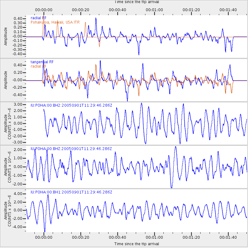
POHA Pohakuloa, Hawaii, USA - Earthquake Result Viewer
*The percent match for this event was below the threshold and hence no stack was calculated.
| Earthquake location: |
South Of Fiji Islands |
| Earthquake latitude/longitude: |
-24.4/179.9 |
| Earthquake time(UTC): |
2005/09/01 (244) 11:22:10 GMT |
| Earthquake Depth: |
513 km |
| Earthquake Magnitude: |
5.6 MW |
| Earthquake Catalog/Contributor: |
NEIC PDE/NEIC PDE-M |
|
| Network: |
IU Global Seismograph Network (GSN - IRIS/USGS) |
| Station: |
POHA Pohakuloa, Hawaii, USA |
| Lat/Lon: |
19.76 N/155.53 W |
| Elevation: |
1967 m |
|
| Distance: |
50.0 deg |
| Az: |
30.752 deg |
| Baz: |
209.664 deg |
| Ray Param: |
$rayparam |
*The percent match for this event was below the threshold and hence was not used in the summary stack. |
|
| Radial Match: |
41.752724 % |
| Radial Bump: |
345 |
| Transverse Match: |
53.68293 % |
| Transverse Bump: |
400 |
| SOD ConfigId: |
590571 |
| Insert Time: |
2013-09-25 15:22:23.742 +0000 |
| GWidth: |
2.5 |
| Max Bumps: |
400 |
| Tol: |
0.001 |
|
Signal To Noise
| Channel | StoN | STA | LTA |
| IU:POHA:00:BHZ:20050901T11:29:46.286Z | 1.187793 | 1.165441E-6 | 9.811819E-7 |
| IU:POHA:00:BH1:20050901T11:29:46.286Z | 2.0718315 | 2.5974482E-6 | 1.2536966E-6 |
| IU:POHA:00:BH2:20050901T11:29:46.286Z | 1.2055733 | 1.1973494E-6 | 9.931784E-7 |
| Arrivals |
| Ps | |
| PpPs | |
| PsPs/PpSs | |


