You are here: Home > Network List > TA - USArray Transportable Network (new EarthScope stations) Stations List
> Station O03E Paynes Creek, CA, USA > Earthquake Result Viewer
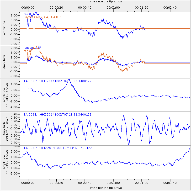
O03E Paynes Creek, CA, USA - Earthquake Result Viewer
*The percent match for this event was below the threshold and hence no stack was calculated.
| Earthquake location: |
Tonga Islands |
| Earthquake latitude/longitude: |
-21.0/-174.2 |
| Earthquake time(UTC): |
2014/10/02 (275) 07:02:05 GMT |
| Earthquake Depth: |
17 km |
| Earthquake Magnitude: |
5.1 MW |
| Earthquake Catalog/Contributor: |
ISC/ISC |
|
| Network: |
TA USArray Transportable Network (new EarthScope stations) |
| Station: |
O03E Paynes Creek, CA, USA |
| Lat/Lon: |
40.29 N/121.80 W |
| Elevation: |
967 m |
|
| Distance: |
78.1 deg |
| Az: |
38.259 deg |
| Baz: |
229.149 deg |
| Ray Param: |
$rayparam |
*The percent match for this event was below the threshold and hence was not used in the summary stack. |
|
| Radial Match: |
41.10385 % |
| Radial Bump: |
400 |
| Transverse Match: |
42.027206 % |
| Transverse Bump: |
400 |
| SOD ConfigId: |
3390531 |
| Insert Time: |
2019-04-14 07:28:53.448 +0000 |
| GWidth: |
2.5 |
| Max Bumps: |
400 |
| Tol: |
0.001 |
|
Signal To Noise
| Channel | StoN | STA | LTA |
| TA:O03E: :HHZ:20141002T07:13:32.340012Z | 0.66233784 | 1.062052E-7 | 1.6034897E-7 |
| TA:O03E: :HHN:20141002T07:13:32.340012Z | 2.0664015 | 8.748497E-7 | 4.2336873E-7 |
| TA:O03E: :HHE:20141002T07:13:32.340012Z | 3.1418116 | 2.5319557E-6 | 8.058904E-7 |
| Arrivals |
| Ps | |
| PpPs | |
| PsPs/PpSs | |


