You are here: Home > Network List > TA - USArray Transportable Network (new EarthScope stations) Stations List
> Station O48A Farmland, IN, USA > Earthquake Result Viewer
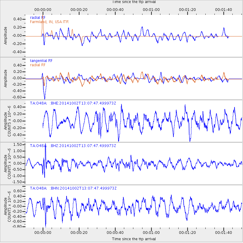
O48A Farmland, IN, USA - Earthquake Result Viewer
*The percent match for this event was below the threshold and hence no stack was calculated.
| Earthquake location: |
Kamchatka Peninsula, Russia |
| Earthquake latitude/longitude: |
52.4/158.0 |
| Earthquake time(UTC): |
2014/10/02 (275) 12:57:06 GMT |
| Earthquake Depth: |
150 km |
| Earthquake Magnitude: |
5.7 MB |
| Earthquake Catalog/Contributor: |
NEIC PDE/NEIC COMCAT |
|
| Network: |
TA USArray Transportable Network (new EarthScope stations) |
| Station: |
O48A Farmland, IN, USA |
| Lat/Lon: |
40.26 N/85.16 W |
| Elevation: |
300 m |
|
| Distance: |
72.7 deg |
| Az: |
45.635 deg |
| Baz: |
325.066 deg |
| Ray Param: |
$rayparam |
*The percent match for this event was below the threshold and hence was not used in the summary stack. |
|
| Radial Match: |
46.511456 % |
| Radial Bump: |
400 |
| Transverse Match: |
69.63608 % |
| Transverse Bump: |
400 |
| SOD ConfigId: |
3390531 |
| Insert Time: |
2019-04-14 07:37:12.152 +0000 |
| GWidth: |
2.5 |
| Max Bumps: |
400 |
| Tol: |
0.001 |
|
Signal To Noise
| Channel | StoN | STA | LTA |
| TA:O48A: :BHZ:20141002T13:07:47.499973Z | 2.1944067 | 4.8921737E-7 | 2.2293833E-7 |
| TA:O48A: :BHN:20141002T13:07:47.499973Z | 1.0745054 | 2.414068E-7 | 2.2466784E-7 |
| TA:O48A: :BHE:20141002T13:07:47.499973Z | 1.2251033 | 2.4268124E-7 | 1.9809042E-7 |
| Arrivals |
| Ps | |
| PpPs | |
| PsPs/PpSs | |


