You are here: Home > Network List > IU - Global Seismograph Network (GSN - IRIS/USGS) Stations List
> Station RSSD Black Hills, South Dakota, USA > Earthquake Result Viewer
RSSD Black Hills, South Dakota, USA - Earthquake Result Viewer
*The percent match for this event was below the threshold and hence no stack was calculated.
| Earthquake location: |
Tonga Islands Region |
| Earthquake latitude/longitude: |
-18.3/-172.4 |
| Earthquake time(UTC): |
2005/10/14 (287) 18:58:09 GMT |
| Earthquake Depth: |
0.9 km |
| Earthquake Magnitude: |
5.5 MB |
| Earthquake Catalog/Contributor: |
WHDF/NEIC |
|
| Network: |
IU Global Seismograph Network (GSN - IRIS/USGS) |
| Station: |
RSSD Black Hills, South Dakota, USA |
| Lat/Lon: |
44.12 N/104.04 W |
| Elevation: |
2060 m |
|
| Distance: |
88.0 deg |
| Az: |
42.07 deg |
| Baz: |
242.105 deg |
| Ray Param: |
$rayparam |
*The percent match for this event was below the threshold and hence was not used in the summary stack. |
|
| Radial Match: |
60.491337 % |
| Radial Bump: |
400 |
| Transverse Match: |
55.337563 % |
| Transverse Bump: |
400 |
| SOD ConfigId: |
590571 |
| Insert Time: |
2013-09-25 16:24:02.162 +0000 |
| GWidth: |
2.5 |
| Max Bumps: |
400 |
| Tol: |
0.001 |
|
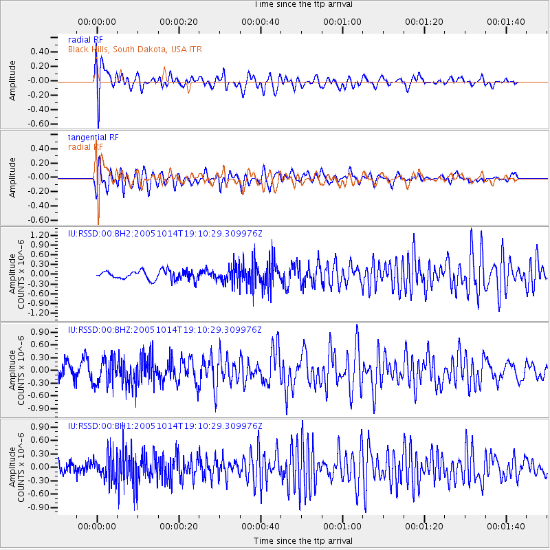
Signal To Noise
| Channel | StoN | STA | LTA |
| IU:RSSD:00:BHZ:20051014T19:10:29.309976Z | 1.7306093 | 3.024687E-7 | 1.7477583E-7 |
| IU:RSSD:00:BH1:20051014T19:10:29.309976Z | 1.9033055 | 2.7956168E-7 | 1.4688219E-7 |
| IU:RSSD:00:BH2:20051014T19:10:29.309976Z | 1.8985837 | 2.5507276E-7 | 1.3434897E-7 |
| Arrivals |
| Ps | |
| PpPs | |
| PsPs/PpSs | |


