You are here: Home > Network List > KZ - Kazakhstan Network Stations List
> Station AKTK Aktyubinsk, Kazakstan > Earthquake Result Viewer
AKTK Aktyubinsk, Kazakstan - Earthquake Result Viewer
| Earthquake location: |
East Of Kuril Islands |
| Earthquake latitude/longitude: |
46.8/154.1 |
| Earthquake time(UTC): |
2005/10/15 (288) 10:06:17 GMT |
| Earthquake Depth: |
43 km |
| Earthquake Magnitude: |
6.0 MB, 5.7 MS, 6.1 MW, 6.0 MW |
| Earthquake Catalog/Contributor: |
WHDF/NEIC |
|
| Network: |
KZ Kazakhstan Network |
| Station: |
AKTK Aktyubinsk, Kazakstan |
| Lat/Lon: |
50.43 N/58.02 E |
| Elevation: |
360 m |
|
| Distance: |
59.2 deg |
| Az: |
312.238 deg |
| Baz: |
52.665 deg |
| Ray Param: |
0.062261 |
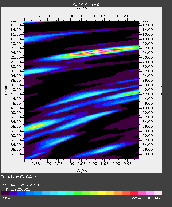
| Estimated Moho Depth: |
23.25 km |
| Estimated Crust Vp/Vs: |
1.92 |
| Assumed Crust Vp: |
6.353 km/s |
| Estimated Crust Vs: |
3.309 km/s |
| Estimated Crust Poisson's Ratio: |
0.31 |
|
| Radial Match: |
85.31244 % |
| Radial Bump: |
400 |
| Transverse Match: |
77.46607 % |
| Transverse Bump: |
400 |
| SOD ConfigId: |
590571 |
| Insert Time: |
2013-09-25 16:25:03.409 +0000 |
| GWidth: |
2.5 |
| Max Bumps: |
400 |
| Tol: |
0.001 |
|

Signal To Noise
| Channel | StoN | STA | LTA |
| KZ:AKTK: :BHZ:20051015T10:15:42.975027Z | 9.232048 | 2.1052297E-6 | 2.2803496E-7 |
| KZ:AKTK: :BH1:20051015T10:15:42.975027Z | 3.3266597 | 5.5369264E-7 | 1.6644103E-7 |
| KZ:AKTK: :BH2:20051015T10:15:42.975027Z | 9.224097 | 1.0574835E-6 | 1.14643576E-7 |
| Arrivals |
| Ps | 3.5 SECOND |
| PpPs | 10 SECOND |
| PsPs/PpSs | 14 SECOND |


