You are here: Home > Network List > IU - Global Seismograph Network (GSN - IRIS/USGS) Stations List
> Station RSSD Black Hills, South Dakota, USA > Earthquake Result Viewer
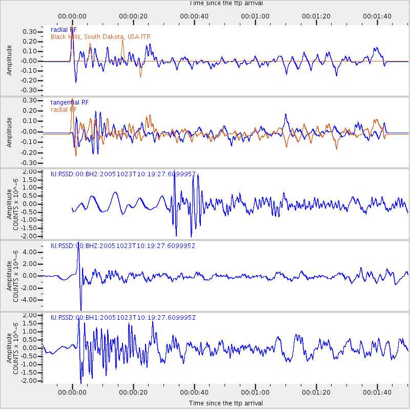
RSSD Black Hills, South Dakota, USA - Earthquake Result Viewer
*The percent match for this event was below the threshold and hence no stack was calculated.
| Earthquake location: |
Sea Of Japan |
| Earthquake latitude/longitude: |
37.4/134.6 |
| Earthquake time(UTC): |
2005/10/23 (296) 10:08:14 GMT |
| Earthquake Depth: |
381 km |
| Earthquake Magnitude: |
5.7 MB, 6.0 MW, 6.0 MW |
| Earthquake Catalog/Contributor: |
WHDF/NEIC |
|
| Network: |
IU Global Seismograph Network (GSN - IRIS/USGS) |
| Station: |
RSSD Black Hills, South Dakota, USA |
| Lat/Lon: |
44.12 N/104.04 W |
| Elevation: |
2060 m |
|
| Distance: |
83.1 deg |
| Az: |
38.257 deg |
| Baz: |
316.774 deg |
| Ray Param: |
$rayparam |
*The percent match for this event was below the threshold and hence was not used in the summary stack. |
|
| Radial Match: |
65.16835 % |
| Radial Bump: |
400 |
| Transverse Match: |
60.70046 % |
| Transverse Bump: |
400 |
| SOD ConfigId: |
590571 |
| Insert Time: |
2013-09-25 16:41:50.625 +0000 |
| GWidth: |
2.5 |
| Max Bumps: |
400 |
| Tol: |
0.001 |
|
Signal To Noise
| Channel | StoN | STA | LTA |
| IU:RSSD:00:BHZ:20051023T10:19:27.609995Z | 6.832928 | 2.2345464E-6 | 3.2702616E-7 |
| IU:RSSD:00:BH1:20051023T10:19:27.609995Z | 3.672158 | 9.000977E-7 | 2.451141E-7 |
| IU:RSSD:00:BH2:20051023T10:19:27.609995Z | 2.250575 | 7.5515163E-7 | 3.3553718E-7 |
| Arrivals |
| Ps | |
| PpPs | |
| PsPs/PpSs | |


