You are here: Home > Network List > IU - Global Seismograph Network (GSN - IRIS/USGS) Stations List
> Station POHA Pohakuloa, Hawaii, USA > Earthquake Result Viewer
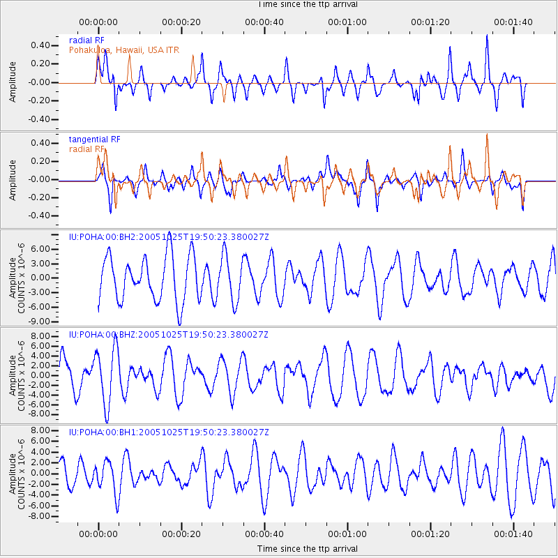
POHA Pohakuloa, Hawaii, USA - Earthquake Result Viewer
*The percent match for this event was below the threshold and hence no stack was calculated.
| Earthquake location: |
Near S Coast Of New Guinea, P.N.G. |
| Earthquake latitude/longitude: |
-7.2/146.0 |
| Earthquake time(UTC): |
2005/10/25 (298) 19:40:43 GMT |
| Earthquake Depth: |
175 km |
| Earthquake Magnitude: |
5.8 MB, 5.9 MW, 5.9 MW |
| Earthquake Catalog/Contributor: |
WHDF/NEIC |
|
| Network: |
IU Global Seismograph Network (GSN - IRIS/USGS) |
| Station: |
POHA Pohakuloa, Hawaii, USA |
| Lat/Lon: |
19.76 N/155.53 W |
| Elevation: |
1967 m |
|
| Distance: |
63.5 deg |
| Az: |
63.844 deg |
| Baz: |
251.031 deg |
| Ray Param: |
$rayparam |
*The percent match for this event was below the threshold and hence was not used in the summary stack. |
|
| Radial Match: |
72.629684 % |
| Radial Bump: |
387 |
| Transverse Match: |
49.552315 % |
| Transverse Bump: |
400 |
| SOD ConfigId: |
590571 |
| Insert Time: |
2013-09-25 16:43:34.917 +0000 |
| GWidth: |
2.5 |
| Max Bumps: |
400 |
| Tol: |
0.001 |
|
Signal To Noise
| Channel | StoN | STA | LTA |
| IU:POHA:00:BHZ:20051025T19:50:23.380027Z | 2.3391225 | 5.9348677E-6 | 2.5372196E-6 |
| IU:POHA:00:BH1:20051025T19:50:23.380027Z | 0.96275777 | 3.0276992E-6 | 3.1448194E-6 |
| IU:POHA:00:BH2:20051025T19:50:23.380027Z | 1.0235932 | 4.7311655E-6 | 4.6221153E-6 |
| Arrivals |
| Ps | |
| PpPs | |
| PsPs/PpSs | |


