You are here: Home > Network List > CI - Caltech Regional Seismic Network Stations List
> Station TIN Tinemaha, Big Pine, CA, USA > Earthquake Result Viewer
TIN Tinemaha, Big Pine, CA, USA - Earthquake Result Viewer
| Earthquake location: |
Near Coast Of Peru |
| Earthquake latitude/longitude: |
-13.5/-76.7 |
| Earthquake time(UTC): |
2006/10/20 (293) 10:48:56 GMT |
| Earthquake Depth: |
23 km |
| Earthquake Magnitude: |
5.9 MB, 6.6 MS, 6.7 MW, 6.6 MW |
| Earthquake Catalog/Contributor: |
WHDF/NEIC |
|
| Network: |
CI Caltech Regional Seismic Network |
| Station: |
TIN Tinemaha, Big Pine, CA, USA |
| Lat/Lon: |
37.05 N/118.23 W |
| Elevation: |
1197 m |
|
| Distance: |
63.7 deg |
| Az: |
323.691 deg |
| Baz: |
133.937 deg |
| Ray Param: |
0.0594048 |
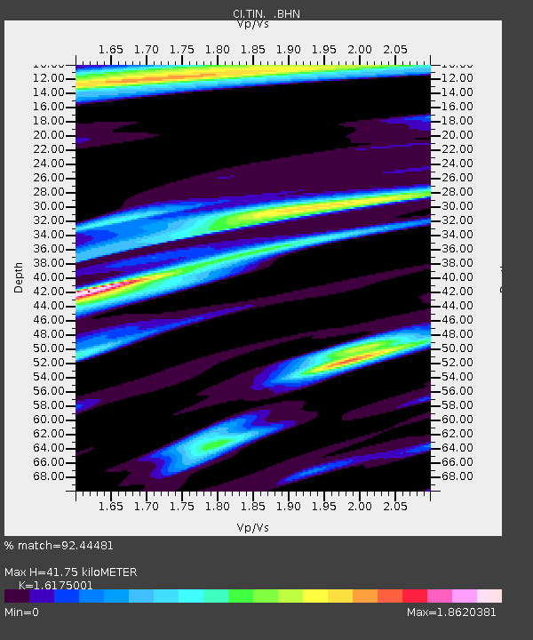
| Estimated Moho Depth: |
41.75 km |
| Estimated Crust Vp/Vs: |
1.62 |
| Assumed Crust Vp: |
6.291 km/s |
| Estimated Crust Vs: |
3.889 km/s |
| Estimated Crust Poisson's Ratio: |
0.19 |
|
| Radial Match: |
92.44481 % |
| Radial Bump: |
400 |
| Transverse Match: |
78.264015 % |
| Transverse Bump: |
400 |
| SOD ConfigId: |
2665 |
| Insert Time: |
2010-02-25 20:44:42.655 +0000 |
| GWidth: |
2.5 |
| Max Bumps: |
400 |
| Tol: |
0.001 |
|
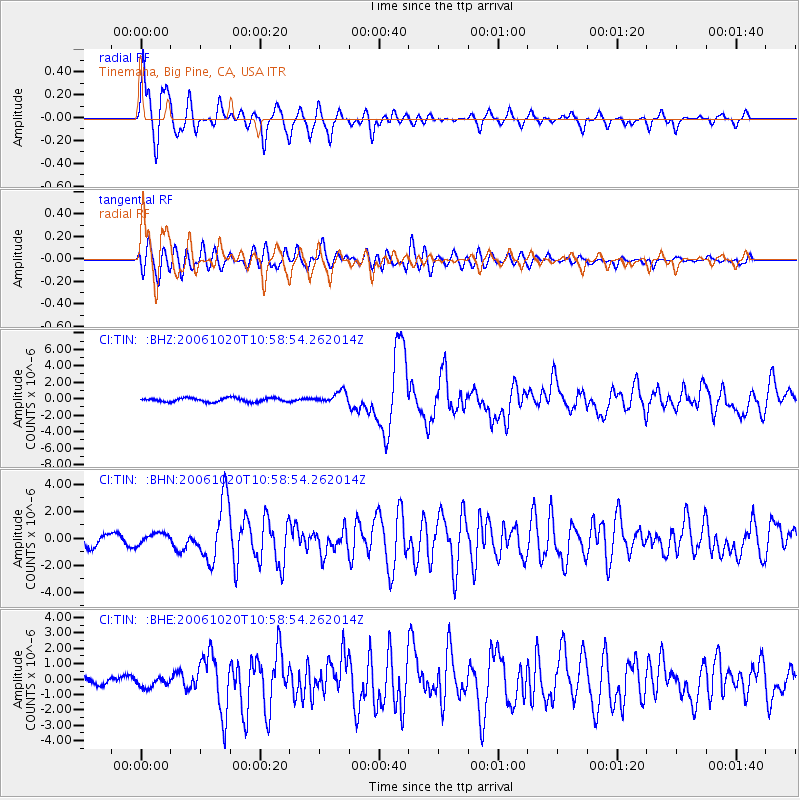
Signal To Noise
| Channel | StoN | STA | LTA |
| CI:TIN: :BHN:20061020T10:58:54.262014Z | 1.0861007 | 4.1887796E-7 | 3.856714E-7 |
| CI:TIN: :BHE:20061020T10:58:54.262014Z | 1.0720065 | 3.150447E-7 | 2.938832E-7 |
| CI:TIN: :BHZ:20061020T10:58:54.262014Z | 2.9224212 | 7.060079E-7 | 2.4158322E-7 |
| Arrivals |
| Ps | 4.3 SECOND |
| PpPs | 17 SECOND |
| PsPs/PpSs | 21 SECOND |


