You are here: Home > Network List > CN - Canadian National Seismograph Network Stations List
> Station YKW1 YKW1, NT, CANADA., CANADA > Earthquake Result Viewer
YKW1 YKW1, NT, CANADA., CANADA - Earthquake Result Viewer
| Earthquake location: |
Off Coast Of Chiapas, Mexico |
| Earthquake latitude/longitude: |
15.0/-94.2 |
| Earthquake time(UTC): |
2006/06/27 (178) 13:03:12 GMT |
| Earthquake Depth: |
29 km |
| Earthquake Magnitude: |
5.4 MB, 5.5 MS, 5.8 MW, 5.8 MW |
| Earthquake Catalog/Contributor: |
WHDF/NEIC |
|
| Network: |
CN Canadian National Seismograph Network |
| Station: |
YKW1 YKW1, NT, CANADA., CANADA |
| Lat/Lon: |
62.48 N/114.48 W |
| Elevation: |
171 m |
|
| Distance: |
49.6 deg |
| Az: |
347.78 deg |
| Baz: |
153.867 deg |
| Ray Param: |
0.06855132 |
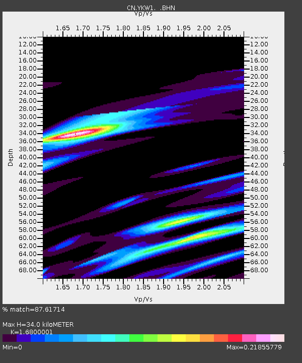
| Estimated Moho Depth: |
34.0 km |
| Estimated Crust Vp/Vs: |
1.68 |
| Assumed Crust Vp: |
6.459 km/s |
| Estimated Crust Vs: |
3.845 km/s |
| Estimated Crust Poisson's Ratio: |
0.23 |
|
| Radial Match: |
87.61714 % |
| Radial Bump: |
400 |
| Transverse Match: |
59.295692 % |
| Transverse Bump: |
400 |
| SOD ConfigId: |
5423 |
| Insert Time: |
2010-02-27 08:09:06.443 +0000 |
| GWidth: |
2.5 |
| Max Bumps: |
400 |
| Tol: |
0.001 |
|
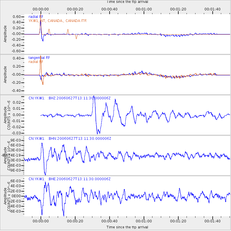
Signal To Noise
| Channel | StoN | STA | LTA |
| CN:YKW1: :BHN:20060627T13:11:30.000006Z | 3.0583098 | 6.0119443E-9 | 1.9657735E-9 |
| CN:YKW1: :BHE:20060627T13:11:30.000006Z | 3.4185123 | 3.886713E-9 | 1.1369604E-9 |
| CN:YKW1: :BHZ:20060627T13:11:30.000006Z | 18.826 | 2.177376E-8 | 1.1565793E-9 |
| Arrivals |
| Ps | 3.8 SECOND |
| PpPs | 13 SECOND |
| PsPs/PpSs | 17 SECOND |


