You are here: Home > Network List > CN - Canadian National Seismograph Network Stations List
> Station YKW1 YKW1, NT, CANADA., CANADA > Earthquake Result Viewer
YKW1 YKW1, NT, CANADA., CANADA - Earthquake Result Viewer
| Earthquake location: |
Northern Mid-Atlantic Ridge |
| Earthquake latitude/longitude: |
33.0/-39.7 |
| Earthquake time(UTC): |
2006/06/18 (169) 18:28:02 GMT |
| Earthquake Depth: |
10 km |
| Earthquake Magnitude: |
5.5 MB, 5.8 MS, 5.9 MW, 5.9 MW |
| Earthquake Catalog/Contributor: |
WHDF/NEIC |
|
| Network: |
CN Canadian National Seismograph Network |
| Station: |
YKW1 YKW1, NT, CANADA., CANADA |
| Lat/Lon: |
62.48 N/114.48 W |
| Elevation: |
171 m |
|
| Distance: |
54.4 deg |
| Az: |
326.527 deg |
| Baz: |
86.0 deg |
| Ray Param: |
0.06550282 |
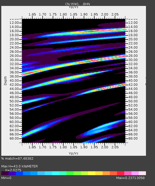
| Estimated Moho Depth: |
43.0 km |
| Estimated Crust Vp/Vs: |
2.03 |
| Assumed Crust Vp: |
6.459 km/s |
| Estimated Crust Vs: |
3.186 km/s |
| Estimated Crust Poisson's Ratio: |
0.34 |
|
| Radial Match: |
87.48382 % |
| Radial Bump: |
398 |
| Transverse Match: |
69.52517 % |
| Transverse Bump: |
400 |
| SOD ConfigId: |
5423 |
| Insert Time: |
2010-02-27 08:09:09.330 +0000 |
| GWidth: |
2.5 |
| Max Bumps: |
400 |
| Tol: |
0.001 |
|
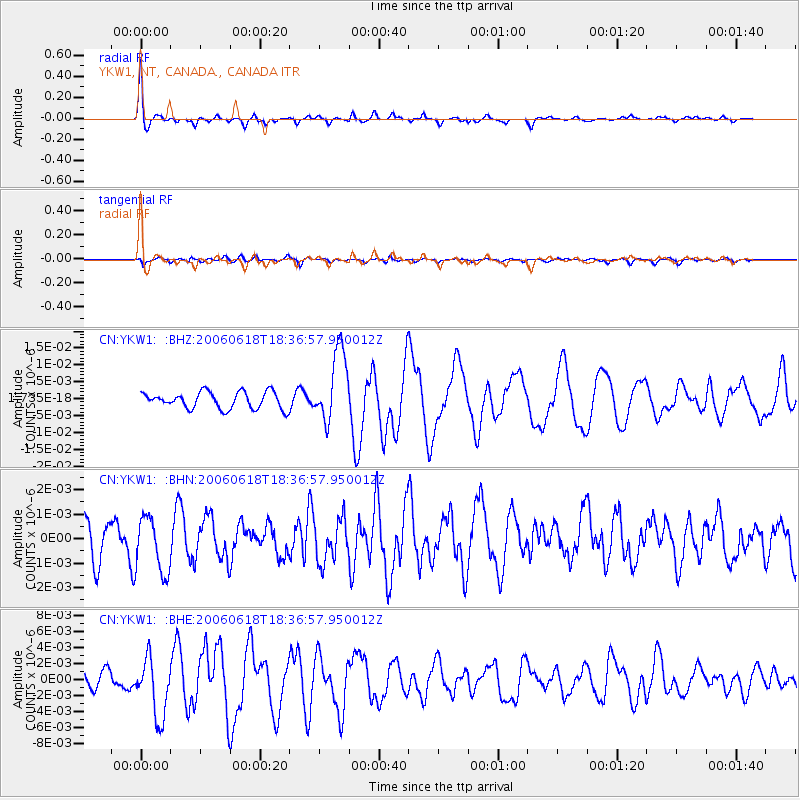
Signal To Noise
| Channel | StoN | STA | LTA |
| CN:YKW1: :BHN:20060618T18:36:57.950012Z | 1.5797672 | 1.1305904E-9 | 7.1566897E-10 |
| CN:YKW1: :BHE:20060618T18:36:57.950012Z | 3.1248682 | 3.7264045E-9 | 1.1924999E-9 |
| CN:YKW1: :BHZ:20060618T18:36:57.950012Z | 4.3318844 | 1.0609008E-8 | 2.4490516E-9 |
| Arrivals |
| Ps | 7.2 SECOND |
| PpPs | 19 SECOND |
| PsPs/PpSs | 26 SECOND |


