You are here: Home > Network List > CN - Canadian National Seismograph Network Stations List
> Station YKW1 YKW1, NT, CANADA., CANADA > Earthquake Result Viewer
YKW1 YKW1, NT, CANADA., CANADA - Earthquake Result Viewer
| Earthquake location: |
Gulf Of California |
| Earthquake latitude/longitude: |
26.9/-111.2 |
| Earthquake time(UTC): |
2006/07/30 (211) 01:20:59 GMT |
| Earthquake Depth: |
10 km |
| Earthquake Magnitude: |
5.3 MB, 5.7 MS, 5.9 MW, 5.9 MW |
| Earthquake Catalog/Contributor: |
WHDF/NEIC |
|
| Network: |
CN Canadian National Seismograph Network |
| Station: |
YKW1 YKW1, NT, CANADA., CANADA |
| Lat/Lon: |
62.48 N/114.48 W |
| Elevation: |
171 m |
|
| Distance: |
35.7 deg |
| Az: |
357.392 deg |
| Baz: |
174.98 deg |
| Ray Param: |
0.07709214 |
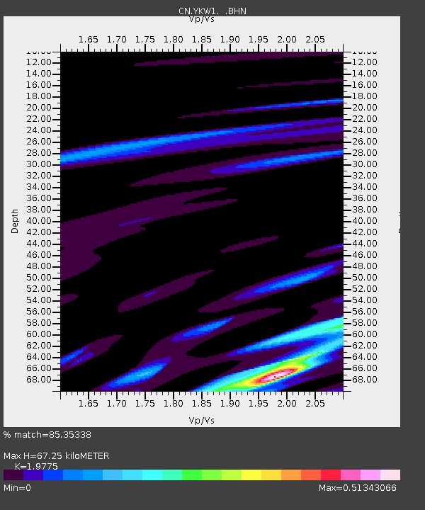
| Estimated Moho Depth: |
67.25 km |
| Estimated Crust Vp/Vs: |
1.98 |
| Assumed Crust Vp: |
6.459 km/s |
| Estimated Crust Vs: |
3.266 km/s |
| Estimated Crust Poisson's Ratio: |
0.33 |
|
| Radial Match: |
85.35338 % |
| Radial Bump: |
400 |
| Transverse Match: |
63.535004 % |
| Transverse Bump: |
400 |
| SOD ConfigId: |
2665 |
| Insert Time: |
2010-02-27 08:09:15.473 +0000 |
| GWidth: |
2.5 |
| Max Bumps: |
400 |
| Tol: |
0.001 |
|
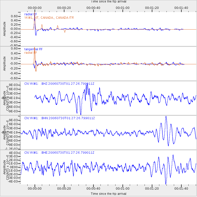
Signal To Noise
| Channel | StoN | STA | LTA |
| CN:YKW1: :BHN:20060730T01:27:26.799011Z | 3.5826516 | 2.2321065E-9 | 6.2303196E-10 |
| CN:YKW1: :BHE:20060730T01:27:26.799011Z | 0.88424164 | 9.47024E-10 | 1.0710014E-9 |
| CN:YKW1: :BHZ:20060730T01:27:26.799011Z | 2.7497513 | 5.177054E-9 | 1.8827353E-9 |
| Arrivals |
| Ps | 11 SECOND |
| PpPs | 29 SECOND |
| PsPs/PpSs | 40 SECOND |


