You are here: Home > Network List > II - Global Seismograph Network (GSN - IRIS/IDA) Stations List
> Station MSEY Mahe, Seychelles > Earthquake Result Viewer
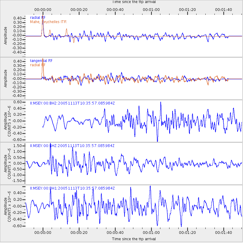
MSEY Mahe, Seychelles - Earthquake Result Viewer
*The percent match for this event was below the threshold and hence no stack was calculated.
| Earthquake location: |
Seram, Indonesia |
| Earthquake latitude/longitude: |
-3.1/128.9 |
| Earthquake time(UTC): |
2005/11/13 (317) 10:24:58 GMT |
| Earthquake Depth: |
20 km |
| Earthquake Magnitude: |
5.8 MB, 5.7 MS, 5.9 MW, 5.9 MW |
| Earthquake Catalog/Contributor: |
WHDF/NEIC |
|
| Network: |
II Global Seismograph Network (GSN - IRIS/IDA) |
| Station: |
MSEY Mahe, Seychelles |
| Lat/Lon: |
4.67 S/55.48 E |
| Elevation: |
475 m |
|
| Distance: |
73.3 deg |
| Az: |
266.073 deg |
| Baz: |
91.827 deg |
| Ray Param: |
$rayparam |
*The percent match for this event was below the threshold and hence was not used in the summary stack. |
|
| Radial Match: |
75.32422 % |
| Radial Bump: |
400 |
| Transverse Match: |
64.05236 % |
| Transverse Bump: |
400 |
| SOD ConfigId: |
590571 |
| Insert Time: |
2013-09-25 17:04:19.854 +0000 |
| GWidth: |
2.5 |
| Max Bumps: |
400 |
| Tol: |
0.001 |
|
Signal To Noise
| Channel | StoN | STA | LTA |
| II:MSEY:00:BHZ:20051113T10:35:57.085984Z | 4.6118517 | 5.1114495E-7 | 1.108329E-7 |
| II:MSEY:00:BH1:20051113T10:35:57.085984Z | 1.4274448 | 1.5586008E-7 | 1.09188164E-7 |
| II:MSEY:00:BH2:20051113T10:35:57.085984Z | 1.2295535 | 1.4229913E-7 | 1.1573238E-7 |
| Arrivals |
| Ps | |
| PpPs | |
| PsPs/PpSs | |


