You are here: Home > Network List > CN - Canadian National Seismograph Network Stations List
> Station YKW1 YKW1, NT, CANADA., CANADA > Earthquake Result Viewer
YKW1 YKW1, NT, CANADA., CANADA - Earthquake Result Viewer

| Earthquake location: |
Tonga Islands |
| Earthquake latitude/longitude: |
-20.2/-174.1 |
| Earthquake time(UTC): |
2006/05/03 (123) 15:26:40 GMT |
| Earthquake Depth: |
55 km |
| Earthquake Magnitude: |
7.2 MB, 7.8 MS, 7.9 MW, 7.9 MW |
| Earthquake Catalog/Contributor: |
WHDF/NEIC |
|
| Network: |
CN Canadian National Seismograph Network |
| Station: |
YKW1 YKW1, NT, CANADA., CANADA |
| Lat/Lon: |
62.48 N/114.48 W |
| Elevation: |
171 m |
|
| Distance: |
94.8 deg |
| Az: |
23.714 deg |
| Baz: |
234.422 deg |
| Ray Param: |
0.040925104 |
| Estimated Moho Depth: |
30.5 km |
| Estimated Crust Vp/Vs: |
1.87 |
| Assumed Crust Vp: |
6.459 km/s |
| Estimated Crust Vs: |
3.45 km/s |
| Estimated Crust Poisson's Ratio: |
0.30 |
|
| Radial Match: |
98.52634 % |
| Radial Bump: |
225 |
| Transverse Match: |
94.93887 % |
| Transverse Bump: |
400 |
| SOD ConfigId: |
2669 |
| Insert Time: |
2010-02-27 08:09:32.693 +0000 |
| GWidth: |
2.5 |
| Max Bumps: |
400 |
| Tol: |
0.001 |
|
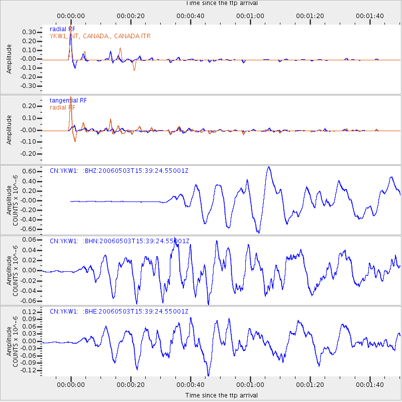
Signal To Noise
| Channel | StoN | STA | LTA |
| CN:YKW1: :BHN:20060503T15:39:24.55001Z | 4.7652698 | 4.2700368E-9 | 8.9607444E-10 |
| CN:YKW1: :BHE:20060503T15:39:24.55001Z | 6.1772766 | 8.100734E-9 | 1.3113763E-9 |
| CN:YKW1: :BHZ:20060503T15:39:24.55001Z | 12.142577 | 4.7172335E-8 | 3.88487E-9 |
| Arrivals |
| Ps | 4.2 SECOND |
| PpPs | 13 SECOND |
| PsPs/PpSs | 18 SECOND |


