You are here: Home > Network List > IU - Global Seismograph Network (GSN - IRIS/USGS) Stations List
> Station RSSD Black Hills, South Dakota, USA > Earthquake Result Viewer
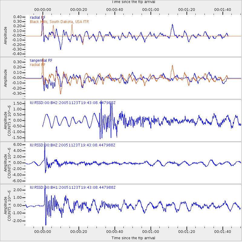
RSSD Black Hills, South Dakota, USA - Earthquake Result Viewer
*The percent match for this event was below the threshold and hence no stack was calculated.
| Earthquake location: |
Sea Of Okhotsk |
| Earthquake latitude/longitude: |
50.1/147.7 |
| Earthquake time(UTC): |
2005/11/23 (327) 19:33:45 GMT |
| Earthquake Depth: |
632 km |
| Earthquake Magnitude: |
5.4 MB, 5.6 MW, 5.6 MW |
| Earthquake Catalog/Contributor: |
WHDF/NEIC |
|
| Network: |
IU Global Seismograph Network (GSN - IRIS/USGS) |
| Station: |
RSSD Black Hills, South Dakota, USA |
| Lat/Lon: |
44.12 N/104.04 W |
| Elevation: |
2060 m |
|
| Distance: |
67.3 deg |
| Az: |
47.826 deg |
| Baz: |
318.467 deg |
| Ray Param: |
$rayparam |
*The percent match for this event was below the threshold and hence was not used in the summary stack. |
|
| Radial Match: |
56.20877 % |
| Radial Bump: |
400 |
| Transverse Match: |
68.81264 % |
| Transverse Bump: |
400 |
| SOD ConfigId: |
590571 |
| Insert Time: |
2013-09-25 17:22:01.687 +0000 |
| GWidth: |
2.5 |
| Max Bumps: |
400 |
| Tol: |
0.001 |
|
Signal To Noise
| Channel | StoN | STA | LTA |
| IU:RSSD:00:BHZ:20051123T19:43:08.447988Z | 4.6006083 | 1.7359956E-6 | 3.7734046E-7 |
| IU:RSSD:00:BH1:20051123T19:43:08.447988Z | 4.4083695 | 1.0247426E-6 | 2.3245389E-7 |
| IU:RSSD:00:BH2:20051123T19:43:08.447988Z | 2.1802099 | 6.703533E-7 | 3.074719E-7 |
| Arrivals |
| Ps | |
| PpPs | |
| PsPs/PpSs | |


