You are here: Home > Network List > CN - Canadian National Seismograph Network Stations List
> Station YKW1 YKW1, NT, CANADA., CANADA > Earthquake Result Viewer
YKW1 YKW1, NT, CANADA., CANADA - Earthquake Result Viewer
| Earthquake location: |
Near East Coast Of Honshu, Japan |
| Earthquake latitude/longitude: |
38.1/142.1 |
| Earthquake time(UTC): |
2005/12/02 (336) 13:13:09 GMT |
| Earthquake Depth: |
29 km |
| Earthquake Magnitude: |
6.1 MB, 6.3 MS, 6.5 MW, 6.4 MW |
| Earthquake Catalog/Contributor: |
WHDF/NEIC |
|
| Network: |
CN Canadian National Seismograph Network |
| Station: |
YKW1 YKW1, NT, CANADA., CANADA |
| Lat/Lon: |
62.48 N/114.48 W |
| Elevation: |
171 m |
|
| Distance: |
62.7 deg |
| Az: |
30.572 deg |
| Baz: |
300.225 deg |
| Ray Param: |
0.060031127 |
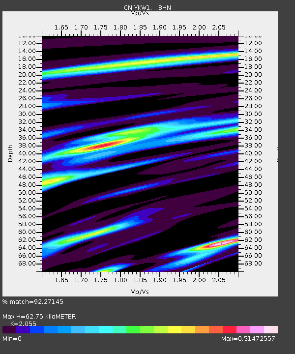
| Estimated Moho Depth: |
62.75 km |
| Estimated Crust Vp/Vs: |
2.06 |
| Assumed Crust Vp: |
6.459 km/s |
| Estimated Crust Vs: |
3.143 km/s |
| Estimated Crust Poisson's Ratio: |
0.34 |
|
| Radial Match: |
92.27145 % |
| Radial Bump: |
259 |
| Transverse Match: |
79.50365 % |
| Transverse Bump: |
391 |
| SOD ConfigId: |
2564 |
| Insert Time: |
2010-02-27 08:09:44.758 +0000 |
| GWidth: |
2.5 |
| Max Bumps: |
400 |
| Tol: |
0.001 |
|

Signal To Noise
| Channel | StoN | STA | LTA |
| CN:YKW1: :BHN:20051202T13:23:00.550029Z | 2.3771093 | 4.425275E-9 | 1.8616203E-9 |
| CN:YKW1: :BHE:20051202T13:23:00.550029Z | 7.397163 | 1.3466068E-8 | 1.8204369E-9 |
| CN:YKW1: :BHZ:20051202T13:23:00.550029Z | 10.53422 | 2.9625722E-8 | 2.812332E-9 |
| Arrivals |
| Ps | 11 SECOND |
| PpPs | 29 SECOND |
| PsPs/PpSs | 39 SECOND |


