You are here: Home > Network List > CN - Canadian National Seismograph Network Stations List
> Station YKW1 YKW1, NT, CANADA., CANADA > Earthquake Result Viewer
YKW1 YKW1, NT, CANADA., CANADA - Earthquake Result Viewer
| Earthquake location: |
Northeast Of Taiwan |
| Earthquake latitude/longitude: |
25.3/123.4 |
| Earthquake time(UTC): |
2005/10/15 (288) 15:51:07 GMT |
| Earthquake Depth: |
183 km |
| Earthquake Magnitude: |
6.2 MB, 6.5 MW, 6.5 MW |
| Earthquake Catalog/Contributor: |
WHDF/NEIC |
|
| Network: |
CN Canadian National Seismograph Network |
| Station: |
YKW1 YKW1, NT, CANADA., CANADA |
| Lat/Lon: |
62.48 N/114.48 W |
| Elevation: |
171 m |
|
| Distance: |
81.2 deg |
| Az: |
23.446 deg |
| Baz: |
309.169 deg |
| Ray Param: |
0.047299538 |
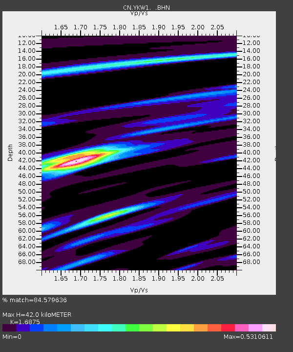
| Estimated Moho Depth: |
42.0 km |
| Estimated Crust Vp/Vs: |
1.69 |
| Assumed Crust Vp: |
6.459 km/s |
| Estimated Crust Vs: |
3.828 km/s |
| Estimated Crust Poisson's Ratio: |
0.23 |
|
| Radial Match: |
84.579636 % |
| Radial Bump: |
299 |
| Transverse Match: |
78.84096 % |
| Transverse Bump: |
400 |
| SOD ConfigId: |
2564 |
| Insert Time: |
2010-02-27 08:09:47.422 +0000 |
| GWidth: |
2.5 |
| Max Bumps: |
400 |
| Tol: |
0.001 |
|

Signal To Noise
| Channel | StoN | STA | LTA |
| CN:YKW1: :BHN:20051015T16:02:31.350015Z | 4.3633323 | 1.1859895E-8 | 2.718082E-9 |
| CN:YKW1: :BHE:20051015T16:02:31.350015Z | 4.927739 | 1.8648608E-8 | 3.7844146E-9 |
| CN:YKW1: :BHZ:20051015T16:02:31.350015Z | 12.607311 | 7.333781E-8 | 5.8170855E-9 |
| Arrivals |
| Ps | 4.6 SECOND |
| PpPs | 17 SECOND |
| PsPs/PpSs | 22 SECOND |


