You are here: Home > Network List > IU - Global Seismograph Network (GSN - IRIS/USGS) Stations List
> Station POHA Pohakuloa, Hawaii, USA > Earthquake Result Viewer
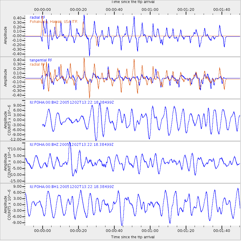
POHA Pohakuloa, Hawaii, USA - Earthquake Result Viewer
*The percent match for this event was below the threshold and hence no stack was calculated.
| Earthquake location: |
Near East Coast Of Honshu, Japan |
| Earthquake latitude/longitude: |
38.1/142.1 |
| Earthquake time(UTC): |
2005/12/02 (336) 13:13:09 GMT |
| Earthquake Depth: |
29 km |
| Earthquake Magnitude: |
6.1 MB, 6.3 MS, 6.5 MW, 6.4 MW |
| Earthquake Catalog/Contributor: |
WHDF/NEIC |
|
| Network: |
IU Global Seismograph Network (GSN - IRIS/USGS) |
| Station: |
POHA Pohakuloa, Hawaii, USA |
| Lat/Lon: |
19.76 N/155.53 W |
| Elevation: |
1967 m |
|
| Distance: |
56.5 deg |
| Az: |
90.233 deg |
| Baz: |
303.095 deg |
| Ray Param: |
$rayparam |
*The percent match for this event was below the threshold and hence was not used in the summary stack. |
|
| Radial Match: |
66.98135 % |
| Radial Bump: |
379 |
| Transverse Match: |
68.33447 % |
| Transverse Bump: |
250 |
| SOD ConfigId: |
590571 |
| Insert Time: |
2013-09-25 17:37:48.683 +0000 |
| GWidth: |
2.5 |
| Max Bumps: |
400 |
| Tol: |
0.001 |
|
Signal To Noise
| Channel | StoN | STA | LTA |
| IU:POHA:00:BHZ:20051202T13:22:18.38499Z | 1.6240143 | 3.4759403E-6 | 2.1403384E-6 |
| IU:POHA:00:BH1:20051202T13:22:18.38499Z | 1.3546612 | 4.070793E-6 | 3.0050267E-6 |
| IU:POHA:00:BH2:20051202T13:22:18.38499Z | 2.7695804 | 8.040953E-6 | 2.903311E-6 |
| Arrivals |
| Ps | |
| PpPs | |
| PsPs/PpSs | |


