You are here: Home > Network List > IU - Global Seismograph Network (GSN - IRIS/USGS) Stations List
> Station RSSD Black Hills, South Dakota, USA > Earthquake Result Viewer
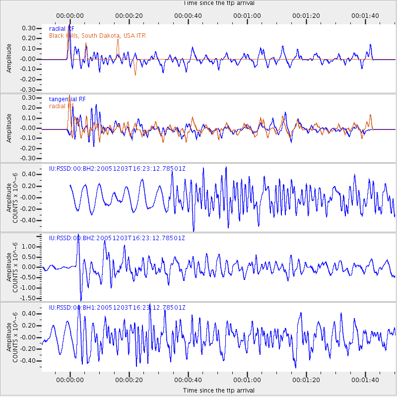
RSSD Black Hills, South Dakota, USA - Earthquake Result Viewer
*The percent match for this event was below the threshold and hence no stack was calculated.
| Earthquake location: |
Ryukyu Islands, Japan |
| Earthquake latitude/longitude: |
29.3/130.3 |
| Earthquake time(UTC): |
2005/12/03 (337) 16:10:42 GMT |
| Earthquake Depth: |
48 km |
| Earthquake Magnitude: |
6.0 MB, 5.7 MS, 6.0 MW, 6.0 MW |
| Earthquake Catalog/Contributor: |
WHDF/NEIC |
|
| Network: |
IU Global Seismograph Network (GSN - IRIS/USGS) |
| Station: |
RSSD Black Hills, South Dakota, USA |
| Lat/Lon: |
44.12 N/104.04 W |
| Elevation: |
2060 m |
|
| Distance: |
91.7 deg |
| Az: |
35.809 deg |
| Baz: |
314.82 deg |
| Ray Param: |
$rayparam |
*The percent match for this event was below the threshold and hence was not used in the summary stack. |
|
| Radial Match: |
69.9754 % |
| Radial Bump: |
400 |
| Transverse Match: |
65.62434 % |
| Transverse Bump: |
400 |
| SOD ConfigId: |
590571 |
| Insert Time: |
2013-09-25 17:40:41.365 +0000 |
| GWidth: |
2.5 |
| Max Bumps: |
400 |
| Tol: |
0.001 |
|
Signal To Noise
| Channel | StoN | STA | LTA |
| IU:RSSD:00:BHZ:20051203T16:23:12.78501Z | 5.8297095 | 7.0233074E-7 | 1.204744E-7 |
| IU:RSSD:00:BH1:20051203T16:23:12.78501Z | 2.5273125 | 2.7871772E-7 | 1.1028225E-7 |
| IU:RSSD:00:BH2:20051203T16:23:12.78501Z | 1.2283108 | 1.9304056E-7 | 1.5715939E-7 |
| Arrivals |
| Ps | |
| PpPs | |
| PsPs/PpSs | |


