You are here: Home > Network List > IU - Global Seismograph Network (GSN - IRIS/USGS) Stations List
> Station RCBR Riachuelo, Brazil > Earthquake Result Viewer
RCBR Riachuelo, Brazil - Earthquake Result Viewer
| Earthquake location: |
Lake Tanganyika Region |
| Earthquake latitude/longitude: |
-6.2/29.8 |
| Earthquake time(UTC): |
2005/12/05 (339) 12:19:56 GMT |
| Earthquake Depth: |
22 km |
| Earthquake Magnitude: |
6.4 MB, 7.2 MS, 6.8 MW, 6.7 MW |
| Earthquake Catalog/Contributor: |
WHDF/NEIC |
|
| Network: |
IU Global Seismograph Network (GSN - IRIS/USGS) |
| Station: |
RCBR Riachuelo, Brazil |
| Lat/Lon: |
5.83 S/35.90 W |
| Elevation: |
409 m |
|
| Distance: |
65.3 deg |
| Az: |
266.452 deg |
| Baz: |
94.161 deg |
| Ray Param: |
0.058317076 |
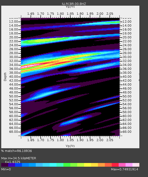
| Estimated Moho Depth: |
34.5 km |
| Estimated Crust Vp/Vs: |
1.63 |
| Assumed Crust Vp: |
6.391 km/s |
| Estimated Crust Vs: |
3.915 km/s |
| Estimated Crust Poisson's Ratio: |
0.20 |
|
| Radial Match: |
96.18936 % |
| Radial Bump: |
389 |
| Transverse Match: |
84.65923 % |
| Transverse Bump: |
400 |
| SOD ConfigId: |
590571 |
| Insert Time: |
2013-09-25 17:45:17.379 +0000 |
| GWidth: |
2.5 |
| Max Bumps: |
400 |
| Tol: |
0.001 |
|
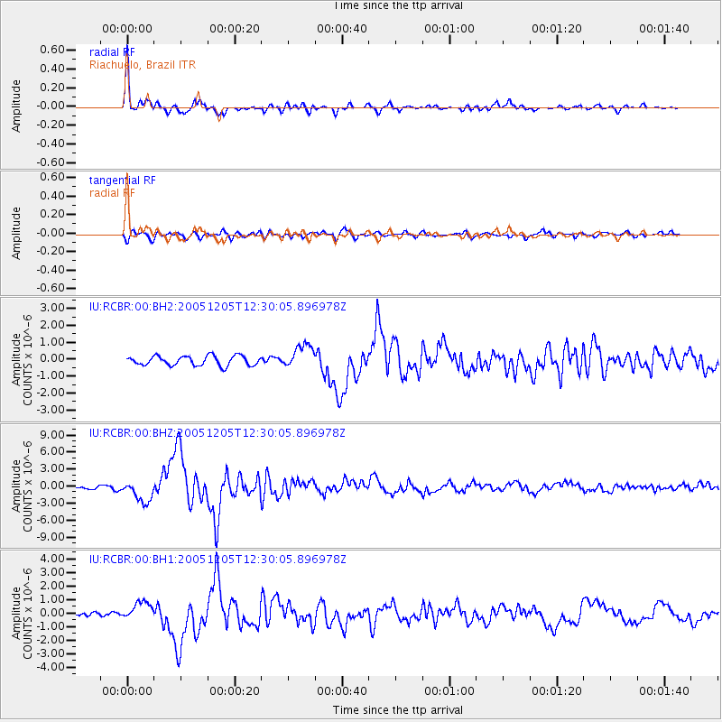
Signal To Noise
| Channel | StoN | STA | LTA |
| IU:RCBR:00:BHZ:20051205T12:30:05.896978Z | 6.4844656 | 1.8936503E-6 | 2.9202874E-7 |
| IU:RCBR:00:BH1:20051205T12:30:05.896978Z | 4.501145 | 6.7910145E-7 | 1.5087305E-7 |
| IU:RCBR:00:BH2:20051205T12:30:05.896978Z | 2.5071428 | 7.007859E-7 | 2.7951575E-7 |
| Arrivals |
| Ps | 3.6 SECOND |
| PpPs | 14 SECOND |
| PsPs/PpSs | 17 SECOND |


